
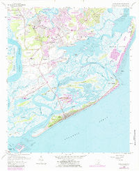
~ James Island SC topo map, 1:24000 scale, 7.5 X 7.5 Minute, Historical, 1959, updated 1984
James Island, South Carolina, USGS topographic map dated 1959.
Includes geographic coordinates (latitude and longitude). This topographic map is suitable for hiking, camping, and exploring, or framing it as a wall map.
Printed on-demand using high resolution imagery, on heavy weight and acid free paper, or alternatively on a variety of synthetic materials.
Topos available on paper, Waterproof, Poly, or Tyvek. Usually shipping rolled, unless combined with other folded maps in one order.
- Product Number: USGS-5686553
- Free digital map download (high-resolution, GeoPDF): James Island, South Carolina (file size: 14 MB)
- Map Size: please refer to the dimensions of the GeoPDF map above
- Weight (paper map): ca. 55 grams
- Map Type: POD USGS Topographic Map
- Map Series: HTMC
- Map Verison: Historical
- Cell ID: 22358
- Scan ID: 261152
- Imprint Year: 1984
- Woodland Tint: Yes
- Photo Revision Year: 1979
- Aerial Photo Year: 1977
- Edit Year: 1979
- Survey Year: 1959
- Datum: NAD27
- Map Projection: Polyconic
- Map published by United States Geological Survey
- Keywords: Overedge with No Adjacent Map
- Map Language: English
- Scanner Resolution: 600 dpi
- Map Cell Name: James Island
- Grid size: 7.5 X 7.5 Minute
- Date on map: 1959
- Map Scale: 1:24000
- Geographical region: South Carolina, United States
Neighboring Maps:
All neighboring USGS topo maps are available for sale online at a variety of scales.
Spatial coverage:
Topo map James Island, South Carolina, covers the geographical area associated the following places:
- Riverpoint - Marsh Point - Green Hill - McCalls Corner - Westchester - Clarks Sound - Woodhaven - Oakcrest - Holiday Acres - Three Trees - Lockwood Hall - Old Orchard - Tidalview - Jamestown Estates - Seaside - Lakeview of Lawton Bluff - Oceanview - Harbor Woods - Dellwood - Landsdowne - Teal Acres - Secessionville - Lighthouse Point - Parrot Point - Stono - Queensborough - Oswald Place - Farmington - Grimball Shores - Fort Johnson Estates - Oakview Park - Stiles Point - Folly Beach - Clarks Point - Lee Jackson Estates - Oyster Point - Whitehouse Plantation - Creek Point - Lynnwood - Greencrest - Bur Clare - Honey Hill - Secessionville Acres - Riverview - Quail Run - Riverland - Centerville - Bayfront - Battery Point - Lawton Bluff - Camp Road Estates - Kings Acres
- Map Area ID: AREA32.7532.625-80-79.875
- Northwest corner Lat/Long code: USGSNW32.75-80
- Northeast corner Lat/Long code: USGSNE32.75-79.875
- Southwest corner Lat/Long code: USGSSW32.625-80
- Southeast corner Lat/Long code: USGSSE32.625-79.875
- Northern map edge Latitude: 32.75
- Southern map edge Latitude: 32.625
- Western map edge Longitude: -80
- Eastern map edge Longitude: -79.875


