
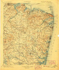
~ Navesink NJ topo map, 1:125000 scale, 30 X 30 Minute, Historical, 1902, updated 1907
Navesink, New Jersey, USGS topographic map dated 1902.
Includes geographic coordinates (latitude and longitude). This topographic map is suitable for hiking, camping, and exploring, or framing it as a wall map.
Printed on-demand using high resolution imagery, on heavy weight and acid free paper, or alternatively on a variety of synthetic materials.
Topos available on paper, Waterproof, Poly, or Tyvek. Usually shipping rolled, unless combined with other folded maps in one order.
- Product Number: USGS-5685953
- Free digital map download (high-resolution, GeoPDF): Navesink, New Jersey (file size: 10 MB)
- Map Size: please refer to the dimensions of the GeoPDF map above
- Weight (paper map): ca. 55 grams
- Map Type: POD USGS Topographic Map
- Map Series: HTMC
- Map Verison: Historical
- Cell ID: 66162
- Scan ID: 255439
- Imprint Year: 1907
- Survey Year: 1885
- Datum: Unstated
- Map Projection: Unstated
- Map published by United States Geological Survey
- Keywords: Overedge with No Adjacent Map
- Map Language: English
- Scanner Resolution: 600 dpi
- Map Cell Name: Navesink
- Grid size: 30 X 30 Minute
- Date on map: 1902
- Map Scale: 1:125000
- Geographical region: New Jersey, United States
Neighboring Maps:
All neighboring USGS topo maps are available for sale online at a variety of scales.
Spatial coverage:
Topo map Navesink, New Jersey, covers the geographical area associated the following places:
- West Osbornsville - Mandalay - Clearbrook Park - Monmouth Heights at Marlboro - West Farms - Gillespie - Bay Harbor Estates - Laurel Park - Winding River Village - Millhurst - Tiltons Corners - Tinton Falls - Ocean Grove - Wyckoffs Mills - Stonehurst West - Colliers Mills - Asbury Park - Vanderburg - Breton Woods - Sea Girt - Blansingburg - Leesville - West Point Pleasant - Manalapan - Saint Vladimirs - Silverton - MacArthur Manor - Adelphia - West Grove - Washington Heights - Oceanport - Leisure Knoll - Allaire - Whittier Oaks - Brookview - Macedonia - Laurence Harbor - Southard - Holmdel - Old Bridge - Pine Lake Park - Fort Hancock - South Mantoloking Beach - Bradley Beach - Spring Lake - Runyon - South Old Bridge - Wayside - Edgemere Estates - Spruce Gardens - Hamilton - Georgia - Greenville - Silverton Estates - Belford - Carmerville - Spotswood Manor - Baileys Corner - Taylors Mills - Oakwood - Englishtown - Shore Acres - Ely - Paulas Corners - Fort Plains - Collingwood Park - Shark River Hills - Osbornes Mills - Belmar - West Deal - Woodruff - North Middletown - Eatontown - West Mantoloking - Red Hill - Cottrell Corners - Greenbriar - Deal Park - Wickatunk - Robinsville - Orchard Estates - Parkway Pines - Cedarwood Park - Maryland - Lake Club - Tracy - Mantoloking Estates - Archers Corner - Crawford Corners - Greensand - Morganville - Van Hiseville - West Belmar - Jamesburg Park - Bradley Park - Silver Bay - Scobeyville - Mount Pleasant - Carrs Corner - Lanes Mills
- Map Area ID: AREA40.540-74.5-74
- Northwest corner Lat/Long code: USGSNW40.5-74.5
- Northeast corner Lat/Long code: USGSNE40.5-74
- Southwest corner Lat/Long code: USGSSW40-74.5
- Southeast corner Lat/Long code: USGSSE40-74
- Northern map edge Latitude: 40.5
- Southern map edge Latitude: 40
- Western map edge Longitude: -74.5
- Eastern map edge Longitude: -74


