
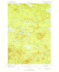
~ Jo Mary Mountain ME topo map, 1:62500 scale, 15 X 15 Minute, Historical, 1952, updated 1955
Jo Mary Mountain, Maine, USGS topographic map dated 1952.
Includes geographic coordinates (latitude and longitude). This topographic map is suitable for hiking, camping, and exploring, or framing it as a wall map.
Printed on-demand using high resolution imagery, on heavy weight and acid free paper, or alternatively on a variety of synthetic materials.
Topos available on paper, Waterproof, Poly, or Tyvek. Usually shipping rolled, unless combined with other folded maps in one order.
- Product Number: USGS-5684423
- Free digital map download (high-resolution, GeoPDF): Jo Mary Mountain, Maine (file size: 8 MB)
- Map Size: please refer to the dimensions of the GeoPDF map above
- Weight (paper map): ca. 55 grams
- Map Type: POD USGS Topographic Map
- Map Series: HTMC
- Map Verison: Historical
- Cell ID: 55888
- Scan ID: 460499
- Imprint Year: 1955
- Woodland Tint: Yes
- Aerial Photo Year: 1947
- Field Check Year: 1952
- Datum: NAD27
- Map Projection: Polyconic
- Map published by United States Geological Survey
- Map Language: English
- Scanner Resolution: 600 dpi
- Map Cell Name: Jo-Mary Mountain
- Grid size: 15 X 15 Minute
- Date on map: 1952
- Map Scale: 1:62500
- Geographical region: Maine, United States
Neighboring Maps:
All neighboring USGS topo maps are available for sale online at a variety of scales.
Spatial coverage:
Topo map Jo Mary Mountain, Maine, covers the geographical area associated the following places:
- T1 R11 WELS - Mud Gauntlet Deadwater - Wadleigh Valley - First Musquash Pond - Deer Brook - Farrar Brook - Hedgehog Pond - Prentiss Brook - B Inlet Brook - Little Shanty Mountain - Turtle Ridge - Little Penobscot Pond - Trestle Brook - Mud Pond - T1 R10 WELS - Jo-Mary Pond - Guernsey Brook - Pratt Brook - Deadwater Brook - Bog Pond - Logan Brook - Third Musquash Pond - Monkey Pond - Gauntlet Brook - Mud Gauntlet Falls - Cedar Pond - Long Pond - Mud Gauntlet Brook - Little Pleasant Pond - Brice Brook - Cooper Mountain - Fourth Roach Pond - Big Pleasant Pond - Female Mountain - Babble Brook - Big Shanty Mountain - Saddleback Mountain - Rocky Pond - Tumbledown Dick Pond - Lower Jo-Mary Lake - Johnston Pond - Wadleigh Mountain - Fox Pond - TA R10 WELS - Church Pond - Wadleigh Pond - Wadleigh Mountain Lookout Tower - Beaver Pond - Big Spruce Mountain - South Inlet Brook - Cooper Brook - Alligator Pond - Twitchell Brook - Yoke Ponds - Nahmakanta Stream - TB R11 WELS - TB R10 WELS - Little Spruce Mountain - Cedar Mountain - Little Wilkie Mountain - B Pond - Leavitt Pond - Hutchinson Pond - Female Pond - Greenwood Pond - Potaywadjo Ridge - Harding Pond - Loon Pond - Duck Pond - Big Wilkie Mountain - Gauntlet Pond - Crawford Pond - Penobscot Pond - Tumbledown Dick Stream - Crater Pond - Sing Sing Pond - Big Boardman Mountain - Round Pond - White Cap Mountain - Third Roach Pond - Rabbit Pond - Spruce Mountain Pond - Henderson Pond - Birch Ridge Ponds - TA R11 WELS - Mountain View Pond - Little Boardman Mountain - Prentiss Pond - Jo-Mary Mountain - Second Musquash Pond - Shanty Mountain Brook - Seventh Roach Pond - Gauntlet Falls - Spruance Pond - Nesuntabunt Mountain - Bear Pond - Cedar Brook - Boardway Ponds - Cooper Pond - Sixth Roach Pond
- Map Area ID: AREA45.7545.5-69.25-69
- Northwest corner Lat/Long code: USGSNW45.75-69.25
- Northeast corner Lat/Long code: USGSNE45.75-69
- Southwest corner Lat/Long code: USGSSW45.5-69.25
- Southeast corner Lat/Long code: USGSSE45.5-69
- Northern map edge Latitude: 45.75
- Southern map edge Latitude: 45.5
- Western map edge Longitude: -69.25
- Eastern map edge Longitude: -69


