
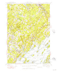
~ Freeport ME topo map, 1:62500 scale, 15 X 15 Minute, Historical, 1941, updated 1957
Freeport, Maine, USGS topographic map dated 1941.
Includes geographic coordinates (latitude and longitude). This topographic map is suitable for hiking, camping, and exploring, or framing it as a wall map.
Printed on-demand using high resolution imagery, on heavy weight and acid free paper, or alternatively on a variety of synthetic materials.
Topos available on paper, Waterproof, Poly, or Tyvek. Usually shipping rolled, unless combined with other folded maps in one order.
- Product Number: USGS-5684247
- Free digital map download (high-resolution, GeoPDF): Freeport, Maine (file size: 8 MB)
- Map Size: please refer to the dimensions of the GeoPDF map above
- Weight (paper map): ca. 55 grams
- Map Type: POD USGS Topographic Map
- Map Series: HTMC
- Map Verison: Historical
- Cell ID: 54394
- Scan ID: 460413
- Imprint Year: 1957
- Woodland Tint: Yes
- Survey Year: 1941
- Datum: NAD27
- Map Projection: Polyconic
- Map published by United States Geological Survey
- Map published by United States Army Corps of Engineers
- Map Language: English
- Scanner Resolution: 600 dpi
- Map Cell Name: Freeport
- Grid size: 15 X 15 Minute
- Date on map: 1941
- Map Scale: 1:62500
- Geographical region: Maine, United States
Neighboring Maps:
All neighboring USGS topo maps are available for sale online at a variety of scales.
Spatial coverage:
Topo map Freeport, Maine, covers the geographical area associated the following places:
- Bustins Island - Lisbon Falls - Deep Cut - West Harpswell - Mast Landing - Pownal Center - Plummer Mill - Yarmouth Junction - Foggs Corner - Freeport - South Freeport - Crockett Corner - South Durham - South West Bend - Sodom - Littlejohn Island - Cousins Island - Lower Village (historical) - Growstown - West Durham - West Pownal - Todds Corners - Pleasant Hill - Yarmouth - Royal Junction - Cumberland Foreside - North Pownal - Pejepscot - Porter Landing - Dunns - Cushing Briggs - Crossman Corner - Walnut Hill - Shiloh - Upper Village (historical) - Hillside - Bunganuc Landing - Merepoint
- Map Area ID: AREA4443.75-70.25-70
- Northwest corner Lat/Long code: USGSNW44-70.25
- Northeast corner Lat/Long code: USGSNE44-70
- Southwest corner Lat/Long code: USGSSW43.75-70.25
- Southeast corner Lat/Long code: USGSSE43.75-70
- Northern map edge Latitude: 44
- Southern map edge Latitude: 43.75
- Western map edge Longitude: -70.25
- Eastern map edge Longitude: -70


