
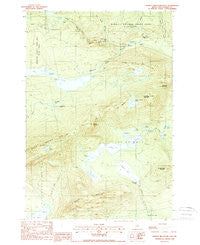
~ Barren Mountain East ME topo map, 1:24000 scale, 7.5 X 7.5 Minute, Historical, 1988, updated 1988
Barren Mountain East, Maine, USGS topographic map dated 1988.
Includes geographic coordinates (latitude and longitude). This topographic map is suitable for hiking, camping, and exploring, or framing it as a wall map.
Printed on-demand using high resolution imagery, on heavy weight and acid free paper, or alternatively on a variety of synthetic materials.
Topos available on paper, Waterproof, Poly, or Tyvek. Usually shipping rolled, unless combined with other folded maps in one order.
- Product Number: USGS-5683739
- Free digital map download (high-resolution, GeoPDF): Barren Mountain East, Maine (file size: 13 MB)
- Map Size: please refer to the dimensions of the GeoPDF map above
- Weight (paper map): ca. 55 grams
- Map Type: POD USGS Topographic Map
- Map Series: HTMC
- Map Verison: Historical
- Cell ID: 69267
- Scan ID: 460154
- Imprint Year: 1988
- Woodland Tint: Yes
- Visual Version Number: 1
- Aerial Photo Year: 1982
- Edit Year: 1988
- Field Check Year: 1984
- Datum: NAD27
- Map Projection: Transverse Mercator
- Provisional map: Yes
- Map published by United States Geological Survey
- Map Language: English
- Scanner Resolution: 600 dpi
- Map Cell Name: Barren Mountain East
- Grid size: 7.5 X 7.5 Minute
- Date on map: 1988
- Map Scale: 1:24000
- Geographical region: Maine, United States
Neighboring Maps:
All neighboring USGS topo maps are available for sale online at a variety of scales.
Spatial coverage:
Topo map Barren Mountain East, Maine, covers the geographical area associated the following places:
- Lucia Pond - The Hermitage Preserve - Lost Pond - Beaver Pond - Barren Mountain - Pugwash Pond - Cloud Pond Brook - Gulf Hagas Trail - Screw Auger Falls - Hays Brook Falls - Boot Pond - Hay Brook - Camp Pond - Dam Pond - Second Narrows - Stair Falls - Lower Deadwater - Gulf Hagas Brook - Hammond Street Pitch - Bear Brook - Chairback Mountain - Barren Mountain Lookout Tower - South Pond - Cloud Pond - Roaring Brook Mountain - East Chairback Pond - West Chairback Pond - Little Wilder Pond - The Hermitage - T7 R9 NWP - Big Wilder Pond - Indian Pond - Buttermilk Falls - First Narrows - Caribou Bog - Duck Cove - The Jaws - Fourth Mountain - Sampson Pond - The Notch - Mud Pond - Billings Falls - Henderson Brook - Columbus Mountain - Rays Mill Pond - Third Mountain - Benson Mountain
- Map Area ID: AREA45.545.375-69.375-69.25
- Northwest corner Lat/Long code: USGSNW45.5-69.375
- Northeast corner Lat/Long code: USGSNE45.5-69.25
- Southwest corner Lat/Long code: USGSSW45.375-69.375
- Southeast corner Lat/Long code: USGSSE45.375-69.25
- Northern map edge Latitude: 45.5
- Southern map edge Latitude: 45.375
- Western map edge Longitude: -69.375
- Eastern map edge Longitude: -69.25


