
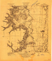
~ Inavale OR topo map, 1:31680 scale, 7.5 X 7.5 Minute, Historical, 1911
Inavale, Oregon, USGS topographic map dated 1911.
Includes geographic coordinates (latitude and longitude). This topographic map is suitable for hiking, camping, and exploring, or framing it as a wall map.
Printed on-demand using high resolution imagery, on heavy weight and acid free paper, or alternatively on a variety of synthetic materials.
Topos available on paper, Waterproof, Poly, or Tyvek. Usually shipping rolled, unless combined with other folded maps in one order.
- Product Number: USGS-5678234
- Free digital map download (high-resolution, GeoPDF): Inavale, Oregon (file size: 11 MB)
- Map Size: please refer to the dimensions of the GeoPDF map above
- Weight (paper map): ca. 55 grams
- Map Type: POD USGS Topographic Map
- Map Series: HTMC
- Map Verison: Historical
- Cell ID: 18369
- Scan ID: 282177
- Survey Year: 1911
- Datum: Unstated
- Map Projection: Unstated
- Advance: Yes
- Map published by United States Geological Survey
- Keywords: Overedge; Nonstandard Press Run
- Map Language: English
- Scanner Resolution: 600 dpi
- Map Cell Name: Greenberry
- Grid size: 7.5 X 7.5 Minute
- Date on map: 1911
- Map Scale: 1:31680
- Geographical region: Oregon, United States
Neighboring Maps:
All neighboring USGS topo maps are available for sale online at a variety of scales.
Spatial coverage:
Topo map Inavale, Oregon, covers the geographical area associated the following places:
- Winkle Cemetery - Greenberry - Reckards (historical) - Starr Creek - Pigeon Butte - Muddy Creek Airport - Winkle Butte - Whitby Ditch - McFadden Marsh - Saxton County Park - Beaver Creek - Armstrong Cemetery - Bruce Post Office (historical) - Southeast Benton Division - Buttes (historical) - Winkle Lake - Barclay (historical) - Bruce - Fern Post Office (historical) - Mill Hill - Philomath Fire and Rescue Station 203 - Rickard - Irwin Cemetery - Shrock - P M Delaubenfelds Dam - Whitaker Lake - Oakridge Cemetery - Rickard Post Office (historical) - Muddy Creek Charter School - Winfield (historical) - Bull Run Creek - Cabell Marsh - Booneville - Coca Cola Airport - McBee Lake - Butte Cemetery - Brown Creek - Baker Lake - P M Delaubenfelds Reservoir - William L Finley National Wildlife Refuge - Gray Creek - Maple Knoll - Inavale Post Office (historical) - Hughes (historical) - Hull Creek - Corvallis Army Air Field (historical) - Buchanan - Venell Airport - Hull Spring - Jennyopolis Post Office (historical) - Statesman Post Office (historical)
- Map Area ID: AREA44.544.375-123.375-123.25
- Northwest corner Lat/Long code: USGSNW44.5-123.375
- Northeast corner Lat/Long code: USGSNE44.5-123.25
- Southwest corner Lat/Long code: USGSSW44.375-123.375
- Southeast corner Lat/Long code: USGSSE44.375-123.25
- Northern map edge Latitude: 44.5
- Southern map edge Latitude: 44.375
- Western map edge Longitude: -123.375
- Eastern map edge Longitude: -123.25


