
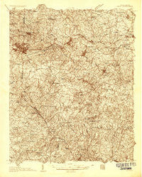
~ Greer SC topo map, 1:48000 scale, 15 X 15 Minute, Historical, 1935
Greer, South Carolina, USGS topographic map dated 1935.
Includes geographic coordinates (latitude and longitude). This topographic map is suitable for hiking, camping, and exploring, or framing it as a wall map.
Printed on-demand using high resolution imagery, on heavy weight and acid free paper, or alternatively on a variety of synthetic materials.
Topos available on paper, Waterproof, Poly, or Tyvek. Usually shipping rolled, unless combined with other folded maps in one order.
- Product Number: USGS-5659446
- Free digital map download (high-resolution, GeoPDF): Greer, South Carolina (file size: 17 MB)
- Map Size: please refer to the dimensions of the GeoPDF map above
- Weight (paper map): ca. 55 grams
- Map Type: POD USGS Topographic Map
- Map Series: HTMC
- Map Verison: Historical
- Cell ID: 54862
- Scan ID: 261758
- Survey Year: 1935
- Datum: NAD27
- Map Projection: Polyconic
- Advance: Yes
- Map published by United States Geological Survey
- Keywords: Nonstandard Press Run; Overedge
- Map Language: English
- Scanner Resolution: 600 dpi
- Map Cell Name: Greer
- Grid size: 15 X 15 Minute
- Date on map: 1935
- Map Scale: 1:48000
- Geographical region: South Carolina, United States
Neighboring Maps:
All neighboring USGS topo maps are available for sale online at a variety of scales.
Spatial coverage:
Topo map Greer, South Carolina, covers the geographical area associated the following places:
- Cove Subdivision - Holiday Hills - Cambridge - Maplewood - Zoar Heights - Cold Spring - Duncan - West Forest - Wellford Estates - Forest Park - Palmetto Estates - Brookhaven - Clevedale - Poplar Springs - Twin Lakes - Chapel Estates - Sunny Glen - Forest Hills - Apalache - Maple - Pine Grove - Fort Prince Farms - Mount Zion - Holly Hill Heights - Country Club Estates - Batesville - Valley Dale Park - Dogwood Acres - Five Forks - Woodland Village - Lakewood Hills - Dillard Crossroads - River Edge - Crestview Hills - Larkin - Ponderosa - Fairmont Mills - Lake Ridge - Hadden Heights - Northview Acres - Brookhaven - Woodland Forest - Victor Mills - Wellford - Cunningham - Fairforest - Oakwood - Snoddy - Pinecrest - Wellington West - Green Pond - Teton Forest - Reidville Acres - Greer - Franklin Village - Shoresbrook - Lakeview Heights - Tyger - Switzer - Reidville - Pinebrook - Lyman - Fairway Estates - Sigsbee - Jackson Mill - Cashville - Palmetto West Mobile Home Park - Calina Heights - Holly Tree - Galloway Trailer Park - Cheryl Fields - Calvert - Cokes Ridge Mobile Home Park - Pelham - Bells Crossroads - Westview Heights - Crescent - Greenridge - Westhaven - Brookside Village - Manning Acres - Fairmont - Startex - Pinnacle Heights - Bellingham - Pleasant Grove - Harveytown - Woodfield - Water Oaks - Mink Creek Estates - Ashley - Homewood Acres - Serene Heights - Gary Creek - Fulton Acres - Hadden Crossroads - Wade Hampton Heights - Brookdale - Bonaire Acres - Victor Heights
- Map Area ID: AREA3534.75-82.25-82
- Northwest corner Lat/Long code: USGSNW35-82.25
- Northeast corner Lat/Long code: USGSNE35-82
- Southwest corner Lat/Long code: USGSSW34.75-82.25
- Southeast corner Lat/Long code: USGSSE34.75-82
- Northern map edge Latitude: 35
- Southern map edge Latitude: 34.75
- Western map edge Longitude: -82.25
- Eastern map edge Longitude: -82


