
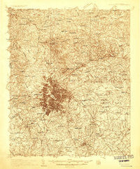
~ Greenville SC topo map, 1:48000 scale, 15 X 15 Minute, Historical, 1935
Greenville, South Carolina, USGS topographic map dated 1935.
Includes geographic coordinates (latitude and longitude). This topographic map is suitable for hiking, camping, and exploring, or framing it as a wall map.
Printed on-demand using high resolution imagery, on heavy weight and acid free paper, or alternatively on a variety of synthetic materials.
Topos available on paper, Waterproof, Poly, or Tyvek. Usually shipping rolled, unless combined with other folded maps in one order.
- Product Number: USGS-5659444
- Free digital map download (high-resolution, GeoPDF): Greenville, South Carolina (file size: 17 MB)
- Map Size: please refer to the dimensions of the GeoPDF map above
- Weight (paper map): ca. 55 grams
- Map Type: POD USGS Topographic Map
- Map Series: HTMC
- Map Verison: Historical
- Cell ID: 54846
- Scan ID: 261757
- Survey Year: 1935
- Datum: NAD27
- Map Projection: Polyconic
- Advance: Yes
- Map published by United States Geological Survey
- Keywords: Nonstandard Press Run; Overedge
- Map Language: English
- Scanner Resolution: 600 dpi
- Map Cell Name: Greenville
- Grid size: 15 X 15 Minute
- Date on map: 1935
- Map Scale: 1:48000
- Geographical region: South Carolina, United States
Neighboring Maps:
All neighboring USGS topo maps are available for sale online at a variety of scales.
Spatial coverage:
Topo map Greenville, South Carolina, covers the geographical area associated the following places:
- Smith Heights - Travelers Rest - Wedgefield - Brookforest Estates - Knollwood - Cane Brake - Spring Forest - Brookfield West - University Ridge Homes - Cleveland Forest - White Oak - Gilstrap Heights - Monaghan - Welcome Acres - Hudson Acres - Wade Hampton - Broadleaf Acres - Sans Souci - Fern Creek - Woodland Homes - East Gantt - Cavalier Woods - Park Lane Terrace - Del Norte - Collins Creek - Sherwood Forest - Pine Hill Village - Dove Tree - Glenwood Acres - Del Norte Estates - Ricelan Creek - Holly Springs - Mountain Shadows - Parkwood - Sans Souci Heights - Paramount Park - Brookside - Supreme Forest - Riley Estates - Pinewood Estates - Minter - New Furman Heights - Groveland Dell - Lake Forest - Mount Vernon Estates - Heritage Lakes - Chanticleer - Berea Heights - Dellwood - Bellwood Estates - Terra Oaks - Birdfield Estates - Mansfield Park - Western Hills - Cope Heights - Sugar Creek - Roosevelt Heights - Fairview - Lorena Park - Poinsett - Oxford Acres - College Heights - Westcliffe - Grey Fox Run - Timberlake - Jamestown Estates - Lake Taro - Seven Oaks - Dellhaven - Burgiss Hills - Silver Leaf - Sunset Forest - Cherokee Forest - Sharon Park - Woodhedge - Orchard Park - Mountain Brook - Overbrook - Woodberry - Rockvale - Palmetto Downs - Traxler Park - Elizabeth Heights - Paris Point - Devenger Place - Conestee - Liberty Park - Parkins Lake - Gantt - Green Forest - Tanglewood - Foxcroft - Pecan Terrace - Glendale - Oak Hills - Westville - Elleston Acres - Carver Park - Woodfield Heights - Quail Ridge
- Map Area ID: AREA3534.75-82.5-82.25
- Northwest corner Lat/Long code: USGSNW35-82.5
- Northeast corner Lat/Long code: USGSNE35-82.25
- Southwest corner Lat/Long code: USGSSW34.75-82.5
- Southeast corner Lat/Long code: USGSSE34.75-82.25
- Northern map edge Latitude: 35
- Southern map edge Latitude: 34.75
- Western map edge Longitude: -82.5
- Eastern map edge Longitude: -82.25


