
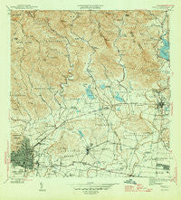
~ Ponce PR topo map, 1:30000 scale, 7.5 X 7.5 Minute, Historical, 1945
Ponce, Puerto Rico, USGS topographic map dated 1945.
Includes geographic coordinates (latitude and longitude). This topographic map is suitable for hiking, camping, and exploring, or framing it as a wall map.
Printed on-demand using high resolution imagery, on heavy weight and acid free paper, or alternatively on a variety of synthetic materials.
Topos available on paper, Waterproof, Poly, or Tyvek. Usually shipping rolled, unless combined with other folded maps in one order.
- Product Number: USGS-5655450
- Free digital map download (high-resolution, GeoPDF): Ponce, Puerto Rico (file size: 11 MB)
- Map Size: please refer to the dimensions of the GeoPDF map above
- Weight (paper map): ca. 55 grams
- Map Type: POD USGS Topographic Map
- Map Series: HTMC
- Map Verison: Historical
- Cell ID: 35930
- Scan ID: 362515
- Visual Version Number: 1
- Datum: Puerto Rico
- Map Projection: Polyconic
- Map published by United States Geological Survey
- Map Language: English
- Scanner Resolution: 600 dpi
- Map Cell Name: Ponce
- Grid size: 7.5 X 7.5 Minute
- Date on map: 1945
- Map Scale: 1:30000
- Geographical region: Puerto Rico, United States
Neighboring Maps:
All neighboring USGS topo maps are available for sale online at a variety of scales.
Spatial coverage:
Topo map Ponce, Puerto Rico, covers the geographical area associated the following places:
- San Antón - Las Monjitas - Jacaranda - Sabanetas - El Bosque - Barriada Jaime L Drew - Sabana Llana Arriba - Sabana Llana Abajo - Hacienda Potala - El Bronce - Mariani - Bélgica - Aguilita - La Alhambra - Hacienda Barrancas - Jagueyes - Vayas - Arús - Jacagua X - Ponce - Calzada Comunidad - Valle Alto - Hacienda Rosalí - Aguilita Comunidad - Glenview - Maragüez - Real Anón - Constancia - Villa Grillasca - Amuelas - Hacienda Ponceña - Los Rosales - Hacienda Usera - Monte Verde Comunidad - Bucaná - La Rambla - Caserio Doctor Gándara - Hacienda Las Magas - Hacienda La Concordia - Hacienda Caño Verde - Hacienda Vista Alegre - Villa Flores - Juana Díaz - Las Lomas - Fagot - Juana Díaz Zona Urbana - Collores - Cerrillos Hoyos Comunidad - Santa Teresita - Los Almendros - Hacienda Restaurada - Ponce de León - Buena Vista - Calzada - Palmarejo - Hacienda Guayo - Hacienda Mercado - Coto Laurel Comunidad - Hacienda Arbona - Vista Alegre - Villa del Sol - Cuatro Calles - Los Caobos - Hacienda Maragüez - Margarita - Jose Tormos Diego - Villa Esperanza - Hacienda Teresa - Hacienda Cintrona Primera - Hacienda Anadón - Caserio Doctor Pila - Villa Campo Alegre - Vayas Comunidad - Hacienda Vertedero - Semil - Borinquen - Hacienda Fé - Salazar - Villa Elena - El Paraiso Comunidad - Santa María - Altavista - Hacienda Arbona - La Ceiba - Hacienda Luciana - Boquerón - Luis Lloréns Torres Comunidad - Rincón - Hacienda Cristina - Ollas Hondas - Real Abajo - El Paraiso - Hacienda Paraíso - Quinta de Monserrate - Extensión Mariani - Hacienda Yani - Ventura - El Vigía - Hacienda Ana María - Guayabal
- Map Area ID: AREA18.12518-66.625-66.5
- Northwest corner Lat/Long code: USGSNW18.125-66.625
- Northeast corner Lat/Long code: USGSNE18.125-66.5
- Southwest corner Lat/Long code: USGSSW18-66.625
- Southeast corner Lat/Long code: USGSSE18-66.5
- Northern map edge Latitude: 18.125
- Southern map edge Latitude: 18
- Western map edge Longitude: -66.625
- Eastern map edge Longitude: -66.5


