
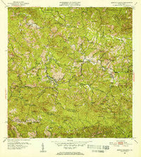
~ Monte Guilarte PR topo map, 1:30000 scale, 7.5 X 7.5 Minute, Historical, 1952, updated 1953
Monte Guilarte, Puerto Rico, USGS topographic map dated 1952.
Includes geographic coordinates (latitude and longitude). This topographic map is suitable for hiking, camping, and exploring, or framing it as a wall map.
Printed on-demand using high resolution imagery, on heavy weight and acid free paper, or alternatively on a variety of synthetic materials.
Topos available on paper, Waterproof, Poly, or Tyvek. Usually shipping rolled, unless combined with other folded maps in one order.
- Product Number: USGS-5655390
- Free digital map download (high-resolution, GeoPDF): Monte Guilarte, Puerto Rico (file size: 14 MB)
- Map Size: please refer to the dimensions of the GeoPDF map above
- Weight (paper map): ca. 55 grams
- Map Type: POD USGS Topographic Map
- Map Series: HTMC
- Map Verison: Historical
- Cell ID: 29910
- Scan ID: 362485
- Imprint Year: 1953
- Woodland Tint: Yes
- Aerial Photo Year: 1941
- Edit Year: 1952
- Field Check Year: 1943
- Datum: Puerto Rico
- Map Projection: Polyconic
- Map published by United States Geological Survey
- Map Language: English
- Scanner Resolution: 600 dpi
- Map Cell Name: Monte Guilarte
- Grid size: 7.5 X 7.5 Minute
- Date on map: 1952
- Map Scale: 1:30000
- Geographical region: Puerto Rico, United States
Neighboring Maps:
All neighboring USGS topo maps are available for sale online at a variety of scales.
Spatial coverage:
Topo map Monte Guilarte, Puerto Rico, covers the geographical area associated the following places:
- Hacienda Noez - Hacienda Américo - Hacienda Pietri - Hacienda Santa María - Hacienda Iberia - Hacienda Bianchi - Hacienda La Juanita - Hacienda Arbela - Hacienda María Antonia - Hacienda Rosario - Castañer - Hacienda La Vega - Hacienda Leonor - Guayabo Dulce - Hacienda Vaquiñas - Hacienda Buena Vista - Hacienda Olivieri - Hacienda San José - Hacienda Ripoll - Hacienda Vilella - Hacienda Santa Clara - Hacienda Santa Anita - Hacienda Concepción - Hacienda Indiera - Hacienda Fortuna - Hacienda Esperanza - Hacienda Santa Rosa - Hacienda Asunción - Hacienda Rivera - Villa Pérez - Hacienda San Lorenzo - Hacienda La Balear - Hacienda Las Piñas - Hacienda San Alberto - Hacienda El Fénix - Hacienda Monserrate - Hacienda Resurrección
- Map Area ID: AREA18.2518.125-66.875-66.75
- Northwest corner Lat/Long code: USGSNW18.25-66.875
- Northeast corner Lat/Long code: USGSNE18.25-66.75
- Southwest corner Lat/Long code: USGSSW18.125-66.875
- Southeast corner Lat/Long code: USGSSE18.125-66.75
- Northern map edge Latitude: 18.25
- Southern map edge Latitude: 18.125
- Western map edge Longitude: -66.875
- Eastern map edge Longitude: -66.75


