
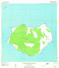
~ Isla Mona PR topo map, 1:20000 scale, 7.5 X 7.5 Minute, Historical, 1944, updated 1963
Isla Mona, Puerto Rico, USGS topographic map dated 1944.
Includes geographic coordinates (latitude and longitude). This topographic map is suitable for hiking, camping, and exploring, or framing it as a wall map.
Printed on-demand using high resolution imagery, on heavy weight and acid free paper, or alternatively on a variety of synthetic materials.
Topos available on paper, Waterproof, Poly, or Tyvek. Usually shipping rolled, unless combined with other folded maps in one order.
- Product Number: USGS-5654790
- Free digital map download (high-resolution, GeoPDF): Isla Mona, Puerto Rico (file size: 8 MB)
- Map Size: please refer to the dimensions of the GeoPDF map above
- Weight (paper map): ca. 55 grams
- Map Type: POD USGS Topographic Map
- Map Series: HTMC
- Map Verison: Historical
- Cell ID: 76885
- Scan ID: 362133
- Imprint Year: 1963
- Woodland Tint: Yes
- Aerial Photo Year: 1944
- Datum: NAD27
- Map Projection: Polyconic
- Map published by United States Geological Survey
- Map published by United States Army
- Map Language: English
- Scanner Resolution: 600 dpi
- Map Cell Name: Isla de Mona
- Grid size: 7.5 X 7.5 Minute
- Date on map: 1944
- Map Scale: 1:20000
- Geographical region: Puerto Rico, United States
Neighboring Maps:
All neighboring USGS topo maps are available for sale online at a variety of scales.
Spatial coverage:
Topo map Isla Mona, Puerto Rico, covers the geographical area associated the following places:
- Isla Monito - Mona Lighthouse - Isla de Mona e Islote Monito Barrio - Anclaje Sardinera - Camino del Faro - Mayagüez Municipio - Playa Sardinera - Camino del Diablo - Punta Los Ingleses - Los Corrales de los Indios - Punta el Capitán - Cabo Noroeste - Cabo el Toro - Punta Brava - Anclaje Isabela - Piedra del Carabinero - Isla de Mona - Punta Este - Camino del Infierno - Punta Caigo o no Caigo - Cabo Barrionuevo - Playa Brava - Playa de Pajaros - Playa del Uvero - Isla de Mona Nature Reserve - Playa Uvero - Punta Arenas
- Map Area ID: AREA18.166666718.0416667-67.9583333-67.8333333
- Northwest corner Lat/Long code: USGSNW18.1666667-67.9583333
- Northeast corner Lat/Long code: USGSNE18.1666667-67.8333333
- Southwest corner Lat/Long code: USGSSW18.0416667-67.9583333
- Southeast corner Lat/Long code: USGSSE18.0416667-67.8333333
- Northern map edge Latitude: 18.1666667
- Southern map edge Latitude: 18.0416667
- Western map edge Longitude: -67.9583333
- Eastern map edge Longitude: -67.8333333


