
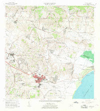
~ Humacao PR topo map, 1:20000 scale, 7.5 X 7.5 Minute, Historical, 1967, updated 1969
Humacao, Puerto Rico, USGS topographic map dated 1967.
Includes geographic coordinates (latitude and longitude). This topographic map is suitable for hiking, camping, and exploring, or framing it as a wall map.
Printed on-demand using high resolution imagery, on heavy weight and acid free paper, or alternatively on a variety of synthetic materials.
Topos available on paper, Waterproof, Poly, or Tyvek. Usually shipping rolled, unless combined with other folded maps in one order.
- Product Number: USGS-5654776
- Free digital map download (high-resolution, GeoPDF): Humacao, Puerto Rico (file size: 19 MB)
- Map Size: please refer to the dimensions of the GeoPDF map above
- Weight (paper map): ca. 55 grams
- Map Type: POD USGS Topographic Map
- Map Series: HTMC
- Map Verison: Historical
- Cell ID: 21430
- Scan ID: 362125
- Imprint Year: 1969
- Woodland Tint: Yes
- Aerial Photo Year: 1964
- Field Check Year: 1967
- Survey Year: 1943
- Datum: Puerto Rico
- Map Projection: Polyconic
- Map published by United States Geological Survey
- Map Language: English
- Scanner Resolution: 600 dpi
- Map Cell Name: Humacao
- Grid size: 7.5 X 7.5 Minute
- Date on map: 1967
- Map Scale: 1:20000
- Geographical region: Puerto Rico, United States
Neighboring Maps:
All neighboring USGS topo maps are available for sale online at a variety of scales.
Spatial coverage:
Topo map Humacao, Puerto Rico, covers the geographical area associated the following places:
- Fermina - Pitahaya - La Suiza - Pasto Viejo - Extension Las Mercedes - Costa Este - Electra - Las Piedras - Antón Ruiz - La Fermina - Duque - Pereyo - Sector Los Garbanzos - Sector La Sabana - Reparto - Buso - Estadio - Las Mercedes - Cometa - Humacao - Los Perros - Roosevelt - Rivera Donato - Villa Universitaria - Maizales - Barriada La Rivera - Boqueron - Gomez - Villa Humacao - Pueblito del Río Comunidad - Los Maestros - Peña Pobre - Alturas de San Benito - Reparto Arenales - Río Blanco Comunidad - Junio - Punta Santiago Comunidad - April Garden - Quintas de Humacao - La Fermina Comunidad - Pueblito del Rio - Melillas - Jardines de Humacao - Río Abajo - Los Pinos - La Pratt - San Antonio - Boquerón Comunidad - Florida - Humacao Zona Urbana - Las Torres - La Fe - Río - San Eladio - Bajandas - El Recreo - Extension Roig - Patagonia - Residencial La Rivera - Jardines de Oriente - El Paraiso - Los Sauces - Peña Pobre Comunidad - Bajandas Comunidad - Las Rosales - Antón Ruíz Comunidad - Santa Teresa - Río Blanco - Las Piedras Zona Urbana - Mayo
- Map Area ID: AREA18.2518.125-65.875-65.75
- Northwest corner Lat/Long code: USGSNW18.25-65.875
- Northeast corner Lat/Long code: USGSNE18.25-65.75
- Southwest corner Lat/Long code: USGSSW18.125-65.875
- Southeast corner Lat/Long code: USGSSE18.125-65.75
- Northern map edge Latitude: 18.25
- Southern map edge Latitude: 18.125
- Western map edge Longitude: -65.875
- Eastern map edge Longitude: -65.75


