
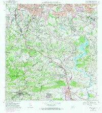
~ Aguas Buenas PR topo map, 1:20000 scale, 7.5 X 7.5 Minute, Historical, 1969, updated 1982
Aguas Buenas, Puerto Rico, USGS topographic map dated 1969.
Includes geographic coordinates (latitude and longitude). This topographic map is suitable for hiking, camping, and exploring, or framing it as a wall map.
Printed on-demand using high resolution imagery, on heavy weight and acid free paper, or alternatively on a variety of synthetic materials.
Topos available on paper, Waterproof, Poly, or Tyvek. Usually shipping rolled, unless combined with other folded maps in one order.
- Product Number: USGS-5654562
- Free digital map download (high-resolution, GeoPDF): Aguas Buenas, Puerto Rico (file size: 24 MB)
- Map Size: please refer to the dimensions of the GeoPDF map above
- Weight (paper map): ca. 55 grams
- Map Type: POD USGS Topographic Map
- Map Series: HTMC
- Map Verison: Historical
- Cell ID: 285
- Scan ID: 362023
- Imprint Year: 1982
- Woodland Tint: Yes
- Visual Version Number: 1
- Photo Revision Year: 1982
- Aerial Photo Year: 1977
- Edit Year: 1982
- Field Check Year: 1969
- Datum: Puerto Rico
- Map Projection: Polyconic
- Map published by United States Geological Survey
- Map Language: English
- Scanner Resolution: 600 dpi
- Map Cell Name: Aguas Buenas
- Grid size: 7.5 X 7.5 Minute
- Date on map: 1969
- Map Scale: 1:20000
- Geographical region: Puerto Rico, United States
Neighboring Maps:
All neighboring USGS topo maps are available for sale online at a variety of scales.
Spatial coverage:
Topo map Aguas Buenas, Puerto Rico, covers the geographical area associated the following places:
- Quebrada Colorado - Beverly Hills - Horizon - Milaville - Parque Bucare II - San Fernando - Riveras de Cupey - Golden Hill - La Changa - Bairoa Golden Gate - Colinas de Fair View - Mansiones de Rio Piedras - Daney - El Senorial - Carraizo Alto - Las Carolinas Comunidad - Round Hill - Rincon Espanol - Paseo Las Vistas - Ponce de León - La Barra - Paseo Real - Trujillo Alto - Residencial Los Alamos - Residencial Mabo - Palmer de Rio - Alturas de Cupey - Sierra Brava - Paseo Alta - Bairoa - Las Carolinas - Terazas de Cupey - Chalets del Parque - Chalet de la Colina - Residencial Jardines de Guaynablo - Romany - La Cumbre - La Esperanza - Bucaré - Villa Clementina - Garcia - Leprocomio - Rio Cristal - San Antonio - Santa Paula - La Bayamonesa - Bosque de Rio - Santa Clara - Estancias de Turabo - Boriquen Gardens - Residencial Interamericana - Extension Padre Quiones - Reparto San Rafael - Canta Gallo - Residencial Vista Alegre - El Mirador - La Liga Comunidad - El Laberinto - Quintas de Parkville - Paseo del Prado - Lomas de Santa Marta - Trujillo Alto Zona Urbana - Mansiones de Villanova - Las Marias - Parque Forestal - San Rafael - Residencial Vistas de Jagueyes - Sierra Berdecia - Saint Just - Colinas de Curry - Barriada San Nicholas - Guaynabo - Ciudad Universitaria - Reparto San Rafael - Valle Verde - Sunville - Bairoa La Veinticinco Comunidad - La Marina - La Alborada - Las Cuevas - Villa del Alar - Villa Escondida - Parkville - Terrazas de Guaynabo - San Gerardo - San Juan Gardens - Litheda - Alturas de Fairview - Monacillo - Paseo Las Brisa - Aguas Buenas Zona Urbana - Muñoz Rivera - Pedro Regalado Diaz - Paseo Mayor - Aguas Buenas - Miradorde Bairea - Golden Gates - Alturas de Inter-Americana - Fairview - Colimar
- Map Area ID: AREA18.37518.25-66.125-66
- Northwest corner Lat/Long code: USGSNW18.375-66.125
- Northeast corner Lat/Long code: USGSNE18.375-66
- Southwest corner Lat/Long code: USGSSW18.25-66.125
- Southeast corner Lat/Long code: USGSSE18.25-66
- Northern map edge Latitude: 18.375
- Southern map edge Latitude: 18.25
- Western map edge Longitude: -66.125
- Eastern map edge Longitude: -66


