
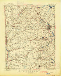
~ Wyoming DE topo map, 1:62500 scale, 15 X 15 Minute, Historical, 1930, updated 1945
Wyoming, Delaware, USGS topographic map dated 1930.
Includes geographic coordinates (latitude and longitude). This topographic map is suitable for hiking, camping, and exploring, or framing it as a wall map.
Printed on-demand using high resolution imagery, on heavy weight and acid free paper, or alternatively on a variety of synthetic materials.
Topos available on paper, Waterproof, Poly, or Tyvek. Usually shipping rolled, unless combined with other folded maps in one order.
- Product Number: USGS-5647727
- Free digital map download (high-resolution, GeoPDF): Wyoming, Delaware (file size: 8 MB)
- Map Size: please refer to the dimensions of the GeoPDF map above
- Weight (paper map): ca. 55 grams
- Map Type: POD USGS Topographic Map
- Map Series: HTMC
- Map Verison: Historical
- Cell ID: 64741
- Scan ID: 255814
- Imprint Year: 1945
- Survey Year: 1926
- Datum: NAD
- Map Projection: Polyconic
- Map published by United States Geological Survey
- Keywords: Overedge
- Map Language: English
- Scanner Resolution: 600 dpi
- Map Cell Name: Wyoming
- Grid size: 15 X 15 Minute
- Date on map: 1930
- Map Scale: 1:62500
- Geographical region: Delaware, United States
Neighboring Maps:
All neighboring USGS topo maps are available for sale online at a variety of scales.
Spatial coverage:
Topo map Wyoming, Delaware, covers the geographical area associated the following places:
- Whispering Pines Mobile Home Park - London Village - Oak Point Acres - Dupont Manor - Oxyoke Mobile Home Park - Edge Hill - Viola Woods - Wedgewood - Oaknoll - Sherwood - Townsend Fields - Bork Acres - Berrytown - White Hall - Andrews Lake Estates - Independence Village - Paden Corner - Derbywood - Woodcrest - The Flying Dutchman Mobile Home Park - Meadow Glen - Warrens Mobile Home Park - Capitol Park - Seeneytown - Forrest Grove Village Mobile Home Park - Candlewicke - Slaughter - Woods Manor East - Paris Villa - Beades Estate - Star Hill - Lakewind III - Choptank Mills - Heatherfield - Woodstock Court - Wooden Bridge - Downs Chapel - Riverview - Forest Landing - Royal Grant - Schoolview - Harrison Knoll - Chapeltown - Quails Nest - Rockland Hills - Rising Sun - Woodbrook - Briar Park - Meadow Ridge - Presidential Courts - Woodfield - Rising Sun Mobile Home Park - Turnkey - The Blades - Capitol Green - Alexanders Village - Lower Moores Corner - Canterbury - The Hamlet - Fairfield Farms - Barclay Farms - Dover Heights - Hidden Pond - Village of Westover - Four Seasons - Cedar Chase - Bechers Brook - Petersburg - Dupont - Lebanon - Cardinal Hills - Cheswold Farms - Garton Development - Marker Estates - Camden - Highland Acres - Pearsons Corner - Voshell Cove - Winmill - Green Acres Mobile Home Park - Star Hill Village - Green Briar - Manchester Square - Shady Lane - Southwood Acres Mobile Home Park - Strimels Mobile Home Park - Edgehill Acres - Del Shire - Everetts Corner - Brookfield - Lexington Mill - Carriage Lane - Edgehill - Browns Corner - Seven Hickories - Wyoming Mills - Orchard Acres - Foxhall Courtside - Sandtown - Burwood Farms
- Map Area ID: AREA39.2539-75.75-75.5
- Northwest corner Lat/Long code: USGSNW39.25-75.75
- Northeast corner Lat/Long code: USGSNE39.25-75.5
- Southwest corner Lat/Long code: USGSSW39-75.75
- Southeast corner Lat/Long code: USGSSE39-75.5
- Northern map edge Latitude: 39.25
- Southern map edge Latitude: 39
- Western map edge Longitude: -75.75
- Eastern map edge Longitude: -75.5


