
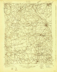
~ Wyoming DE topo map, 1:48000 scale, 15 X 15 Minute, Historical, 1926
Wyoming, Delaware, USGS topographic map dated 1926.
Includes geographic coordinates (latitude and longitude). This topographic map is suitable for hiking, camping, and exploring, or framing it as a wall map.
Printed on-demand using high resolution imagery, on heavy weight and acid free paper, or alternatively on a variety of synthetic materials.
Topos available on paper, Waterproof, Poly, or Tyvek. Usually shipping rolled, unless combined with other folded maps in one order.
- Product Number: USGS-5647723
- Free digital map download (high-resolution, GeoPDF): Wyoming, Delaware (file size: 12 MB)
- Map Size: please refer to the dimensions of the GeoPDF map above
- Weight (paper map): ca. 55 grams
- Map Type: POD USGS Topographic Map
- Map Series: HTMC
- Map Verison: Historical
- Cell ID: 64741
- Scan ID: 255726
- Survey Year: 1926
- Datum: NAD
- Map Projection: Polyconic
- Advance: Yes
- Map published by United States Geological Survey
- Keywords: Overedge; Nonstandard Press Run
- Map Language: English
- Scanner Resolution: 600 dpi
- Map Cell Name: Wyoming
- Grid size: 15 X 15 Minute
- Date on map: 1926
- Map Scale: 1:48000
- Geographical region: Delaware, United States
Neighboring Maps:
All neighboring USGS topo maps are available for sale online at a variety of scales.
Spatial coverage:
Topo map Wyoming, Delaware, covers the geographical area associated the following places:
- Northridge - Hickory Dale Acres - Hammville - Whigville - Crossgates - Summerfield Village - Canterville - Lower Moores Corner - Green Briar - Leipsic - Felton - The Blades - Foxhall Courtside - Shady Lane - Fox Hall - Hudson Trails - Riverview - Manchester Square - Palmer Park - Forest Gate - Brookfield - Greenview - Lakewind - Lebanon - Berrytown - Pinewood Acres Mobile Home Park - Cardinal Hills - Seeneytown - Wooden Bridge - Beech Haven - Hourglass - Oak Point Acres - Lincoln Park - Warrens Mobile Home Park - The Flying Dutchman Mobile Home Park - Kenton - Carlisle Village - Garton Development - Woodbrook - Cheswold - Chaplecroft - Hidden Acres - Pennwood - Cedar Chase - Edgehill Acres - Cheswold Farms - Padens Corner Mobile Home Park - Four Seasons - Paris Villa - Presidential Courts - Davis Corner - Melbourne Manor - Bethel - Highland Acres - Rodney Village - Chimney Hill - Woods Manor - Choptank Mills - Hazelwood - Viola - Lexington Mill - Rodric Village - Marker Estates - Harrison Knoll - Woodfield - Forrest Grove Village Mobile Home Park - Green Acres Mobile Home Park - Granada Mobile Home Park - Breezewood - Shaws Corner - Mayfair - Dinahs Corner - Laurel Bend - Canterbury - Coopers Corner - Shorts Corner - Mallard Pond - Felton Station - Edge Hill - Rising Sun Mobile Home Park - Townsend Fields - Seven Hickories - Dover - Taylor Estates - Rolling Meadows - Tidbury Manor - Derby Shores - Woodcrest - Rockland West - Derbywood - Winmill - Towne Point - Independence Village - Willow Grove - Meadow Ridge - Normansmeade - Tidbury Creek Park Mobile Home Park - Lakewind III - Sandtown - Rehak
- Map Area ID: AREA39.2539-75.75-75.5
- Northwest corner Lat/Long code: USGSNW39.25-75.75
- Northeast corner Lat/Long code: USGSNE39.25-75.5
- Southwest corner Lat/Long code: USGSSW39-75.75
- Southeast corner Lat/Long code: USGSSE39-75.5
- Northern map edge Latitude: 39.25
- Southern map edge Latitude: 39
- Western map edge Longitude: -75.75
- Eastern map edge Longitude: -75.5


