
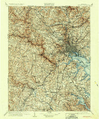
~ Patapsco MD topo map, 1:125000 scale, 30 X 30 Minute, Historical, 1908, updated 1934
Patapsco, Maryland, USGS topographic map dated 1908.
Includes geographic coordinates (latitude and longitude). This topographic map is suitable for hiking, camping, and exploring, or framing it as a wall map.
Printed on-demand using high resolution imagery, on heavy weight and acid free paper, or alternatively on a variety of synthetic materials.
Topos available on paper, Waterproof, Poly, or Tyvek. Usually shipping rolled, unless combined with other folded maps in one order.
- Product Number: USGS-5637877
- Free digital map download (high-resolution, GeoPDF): Patapsco, Maryland (file size: 13 MB)
- Map Size: please refer to the dimensions of the GeoPDF map above
- Weight (paper map): ca. 55 grams
- Map Type: POD USGS Topographic Map
- Map Series: HTMC
- Map Verison: Historical
- Cell ID: 395854
- Scan ID: 257736
- Imprint Year: 1934
- Survey Year: 1906
- Datum: NAD
- Map Projection: Polyconic
- Map published by United States Geological Survey
- Map Language: English
- Scanner Resolution: 600 dpi
- Map Cell Name: Patapsco
- Grid size: 30 X 30 Minute
- Date on map: 1908
- Map Scale: 1:125000
- Geographical region: Maryland, United States
Neighboring Maps:
All neighboring USGS topo maps are available for sale online at a variety of scales.
Spatial coverage:
Topo map Patapsco, Maryland, covers the geographical area associated the following places:
- Hammonds Promise - Elmhurst Ridge - Chatham - Lake Village - Swansfield - Summer Hill - Woodside Square - Locust Manor - Redbridge - Old Mill - Dayton - Brampton Hills - Summerfield Farms - Sunnyview Acres - Beachwood Grove - Tydings - Parkside Heights - Dumbarton - Riverside - High Ridge - Norwich Acres - Quail Ridge - Northwind Village - Chesterfield - Rolling Acres - Lake Hills - West Elkridge - Benson - Hunters Glen - Kingston Heights - Offutt Ridge - Mountain Estates - Phelps Luck - Arundel Beach - Ridgemar - Royal Beach - Brookfield - Good Hope Estates - Oak Hill - Carroll Highlands - Crownsville - Nottingham - Cowdensville - The Terraces - Birchwood Gardens - Sellman Estates - Long Meadow West - Holly Tree Estates - Linton Springs - Sunrise Beach - Knoll View Acres - Centennial Lake - Rockhill Beach - Guilford Gardens - Timberline Park - Bells Mobile Home Park - Eastpoint - Elkhorn - Stevenson - Evergreen - Washington Manor - Emory Grove - Worthington Meadows - Montpelier Hills - Ashland - Winans (historical) - Lime Kiln Valley - Augusta Acres - Cedars - Chapel Hill - Saint Denis - Heritage Hill - Sunset Hill - Elkridge Mobile Home Park - Settlers Landing - Hemlock Hill - Wexford - Stonebrook - Andorick Acres - Carney - Woodcroft - Deer Park - Villa Cresta - Belvedere Heights - Cape Sable - Salopha - Brooklyn Terrace - Linwood - Glen Cove Estates - Woodlawn Heights - Southland Hills - Joyce Acres - Eagles Loft - Village of Painters Mill - Sewells Orchard - Cromwell Fountain - Bonnie Brae - Wellwood - Ashcroft - High View Estates
- Map Area ID: AREA39.539-77-76.5
- Northwest corner Lat/Long code: USGSNW39.5-77
- Northeast corner Lat/Long code: USGSNE39.5-76.5
- Southwest corner Lat/Long code: USGSSW39-77
- Southeast corner Lat/Long code: USGSSE39-76.5
- Northern map edge Latitude: 39.5
- Southern map edge Latitude: 39
- Western map edge Longitude: -77
- Eastern map edge Longitude: -76.5


