
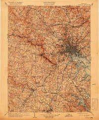
~ Patapsco MD topo map, 1:125000 scale, 30 X 30 Minute, Historical, 1908, updated 1918
Patapsco, Maryland, USGS topographic map dated 1908.
Includes geographic coordinates (latitude and longitude). This topographic map is suitable for hiking, camping, and exploring, or framing it as a wall map.
Printed on-demand using high resolution imagery, on heavy weight and acid free paper, or alternatively on a variety of synthetic materials.
Topos available on paper, Waterproof, Poly, or Tyvek. Usually shipping rolled, unless combined with other folded maps in one order.
- Product Number: USGS-5637875
- Free digital map download (high-resolution, GeoPDF): Patapsco, Maryland (file size: 12 MB)
- Map Size: please refer to the dimensions of the GeoPDF map above
- Weight (paper map): ca. 55 grams
- Map Type: POD USGS Topographic Map
- Map Series: HTMC
- Map Verison: Historical
- Cell ID: 395854
- Scan ID: 257734
- Imprint Year: 1918
- Survey Year: 1906
- Datum: Unstated
- Map Projection: Unstated
- Map published by United States Geological Survey
- Map Language: English
- Scanner Resolution: 600 dpi
- Map Cell Name: Patapsco
- Grid size: 30 X 30 Minute
- Date on map: 1908
- Map Scale: 1:125000
- Geographical region: Maryland, United States
Neighboring Maps:
All neighboring USGS topo maps are available for sale online at a variety of scales.
Spatial coverage:
Topo map Patapsco, Maryland, covers the geographical area associated the following places:
- Lutherville - Cottage Grove Beach - Pines-on-Severn - Herald Harbor - Baldwin Hills South - Hilton (historical) - Hernwood - Burnt Mills Hills - Town and Country - Deer Park - Epping Farms - Rosemont - Candlewick - Iglehart - Contee - Scotts Level - High Point - Fairland Estates - Fairhaven - New Cut Farms - East Springbrook - Fields of Stevenson - Heritage Heights - Cromwell Station - Dembeigh Hill - Cresthaven - Chesmar - Chriswood Manor - Sarawoods - Jackson Grove - Saint Stephens Estates - Charing Cross - Chateau Valley - Maynadier - Harmans Woods - Corridor North - Glyndon - Michaelton Manor - Ridge Grove - Hollofield - Morgan Park - Westerlee - Andorick Acres - Thompsons Purchase - O'Donnell Heights - Milford - Oak Hill - Satyr Hill Estates - Windsor Mill - Ridgeway - Worthington Club Estates - Lake Riviera - Ramsgate News (not official) - Orchard Gate at Piney Orchard - Terrace View Estates - Obretch Estates - Patuxent Riding - North Farm - Masonville (historical) - O'Donnell - Rippling Estates - Foxridge - Parkway Hills Mobile Home Park - Leishear Knolls - Daniels - Jessup - Lindamoor on the Severn - Ivy Hill - Harristown - Rolling Acres - Magothy Forge - Minersville (historical) - Glen Burnie - Mayfield - Knollcrest Farms - Rose Mary Estates - Burtonsville - High Ridge - Hunt Club Estates - Leahigh - Hawthorn - College Station - Cabin Hill - Presidential Park - Holly Point - Chapelview - Alberton (historical) - Parkville - Brightwood - Euclid Heights - Kings Heights - Chestnut Hills - Cresston Park - Ruxton - Solley - Villa Verdi - Holabird Homes (historical) - Four Seasons Estates - Royal Beach - Marshalee Estates
- Map Area ID: AREA39.539-77-76.5
- Northwest corner Lat/Long code: USGSNW39.5-77
- Northeast corner Lat/Long code: USGSNE39.5-76.5
- Southwest corner Lat/Long code: USGSSW39-77
- Southeast corner Lat/Long code: USGSSE39-76.5
- Northern map edge Latitude: 39.5
- Southern map edge Latitude: 39
- Western map edge Longitude: -77
- Eastern map edge Longitude: -76.5


