
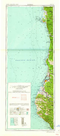
~ Eureka CA topo map, 1:250000 scale, 2 X 1 Degree, Historical, 1961, updated 1961
Eureka, California, USGS topographic map dated 1961.
Includes geographic coordinates (latitude and longitude). This topographic map is suitable for hiking, camping, and exploring, or framing it as a wall map.
Printed on-demand using high resolution imagery, on heavy weight and acid free paper, or alternatively on a variety of synthetic materials.
Topos available on paper, Waterproof, Poly, or Tyvek. Usually shipping rolled, unless combined with other folded maps in one order.
- Product Number: USGS-5630981
- Free digital map download (high-resolution, GeoPDF): Eureka, California (file size: 10 MB)
- Map Size: please refer to the dimensions of the GeoPDF map above
- Weight (paper map): ca. 55 grams
- Map Type: POD USGS Topographic Map
- Map Series: HTMC
- Map Verison: Historical
- Cell ID: 395577
- Scan ID: 299767
- Imprint Year: 1961
- Woodland Tint: Yes
- Field Check Year: 1958
- Datum: Unstated
- Map Projection: Transverse Mercator
- Map published by United States Army Corps of Engineers
- Map published by United States Army
- Map Language: English
- Scanner Resolution: 600 dpi
- Map Cell Name: Eureka
- Grid size: 2 X 1 Degree
- Date on map: 1961
- Map Scale: 1:250000
- Geographical region: California, United States
Neighboring Maps:
All neighboring USGS topo maps are available for sale online at a variety of scales.
Spatial coverage:
Topo map Eureka, California, covers the geographical area associated the following places:
- Scotia - Big Lagoon - Elinor (historical) - Hookton - Pine Hills - Capetown - Westlund Place - Arcata - Smith River - West Humboldt (historical) - Hacketsville - Fernbridge - Elk River - Klamath - Newburg - Shumig (historical) - Fieldbrook - Ore'q (historical) - Clam Beach - Tsurau (historical) - Southport Landing - Khoonkhwuttunne (historical) - Pacific Shores - Moonstone - Spruce Point - Port Kenyon - Loleta - False Klamath - Trinidad - Stafford - Tyee City - Pine Hill - Hunter Place - King Salmon - Fortuna - Hydesville - Elk Grove (historical) - Freshwater Corners - Fort Dick - Douglas Park - Waukell Flat (historical) - Fickle Hill - Table Bluff Rancheria - Beatrice - Khwunrghunme (historical) - Hoppaw - Yontocket - Orick - Bayview - Petrolia - Indianola - Waddington - Bayside - Sunny Brae - Ocean West Mobile Home Park - Ferndale - Metropolitan - Rekwoi (historical) - Worswick - The Springs - Westhaven - Samoa - Shelter Cove - Bucksport - Fisher - Myrtletown - Scott Place - Korblex - Centerville (historical) - Bull Creek - Alton - Eureka - Berry Glenn - Brainard - Belleview - Crannell - Eddyville (historical) - Patricks Point - Manila - Freshwater - Indianola - Essex - Crescent City - Stone - Calville - Requa - Cutten - Tryon Corner - Glendale - McKinleyville - Fields Landing - Arlynda Corners - Rosewood - Hiouchi - Fairhaven - Carlotta - Alliance - Table Bluff - Rio Dell - Bracut
- Map Area ID: AREA4240-125-124
- Northwest corner Lat/Long code: USGSNW42-125
- Northeast corner Lat/Long code: USGSNE42-124
- Southwest corner Lat/Long code: USGSSW40-125
- Southeast corner Lat/Long code: USGSSE40-124
- Northern map edge Latitude: 42
- Southern map edge Latitude: 40
- Western map edge Longitude: -125
- Eastern map edge Longitude: -124


