
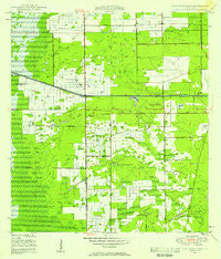
~ West Dixie Bend FL topo map, 1:24000 scale, 7.5 X 7.5 Minute, Historical, 1946, updated 1958
West Dixie Bend, Florida, USGS topographic map dated 1946.
Includes geographic coordinates (latitude and longitude). This topographic map is suitable for hiking, camping, and exploring, or framing it as a wall map.
Printed on-demand using high resolution imagery, on heavy weight and acid free paper, or alternatively on a variety of synthetic materials.
Topos available on paper, Waterproof, Poly, or Tyvek. Usually shipping rolled, unless combined with other folded maps in one order.
- Product Number: USGS-5628778
- Free digital map download (high-resolution, GeoPDF): West Dixie Bend, Florida (file size: 10 MB)
- Map Size: please refer to the dimensions of the GeoPDF map above
- Weight (paper map): ca. 55 grams
- Map Type: POD USGS Topographic Map
- Map Series: HTMC
- Map Verison: Historical
- Cell ID: 48170
- Scan ID: 349043
- Imprint Year: 1958
- Woodland Tint: Yes
- Aerial Photo Year: 1942
- Field Check Year: 1946
- Survey Year: 1946
- Datum: NAD27
- Map Projection: Polyconic
- Map published by United States Geological Survey
- Map published by United States Department of Commerce
- Map Language: English
- Scanner Resolution: 600 dpi
- Map Cell Name: West Dixie Bend
- Grid size: 7.5 X 7.5 Minute
- Date on map: 1946
- Map Scale: 1:24000
- Geographical region: Florida, United States
Neighboring Maps:
All neighboring USGS topo maps are available for sale online at a variety of scales.
Spatial coverage:
Topo map West Dixie Bend, Florida, covers the geographical area associated the following places:
- Rancho Margate Mobile Home Park - Sandalfoot Cove - West Dixie Bend - West Deerfield Beach - Woodsetter North - Lakeview - Whispering Pines Addition Mobile Home Park - Deerfield Lake Mobile Home Park - Leisureville - Hillsboro Mobile Home Park - Country Lakes Community Mobile Home Park - Parkland - Mission Bay - Bonnie Loch - Coral Cay Plantation Mobile Home Park - Hometown Country Lakes Mobile Home Park - Paradise Palms - Sanders Park - Coconut Creek - Parkridge Mobile Home Park - Tallowwood Isle Mobile Home Park - Tidewater Estates Mobile Home Park - Coral Lake Mobile Home Park - Country Knolls Mobile Home Park - Crystal Lake - Loch Lomond - Boca Del Mar - Hillsboro Ranches - Carver Village - Boca Pointe - Hillsboro Pines
- Map Area ID: AREA26.37526.25-80.25-80.125
- Northwest corner Lat/Long code: USGSNW26.375-80.25
- Northeast corner Lat/Long code: USGSNE26.375-80.125
- Southwest corner Lat/Long code: USGSSW26.25-80.25
- Southeast corner Lat/Long code: USGSSE26.25-80.125
- Northern map edge Latitude: 26.375
- Southern map edge Latitude: 26.25
- Western map edge Longitude: -80.25
- Eastern map edge Longitude: -80.125


