
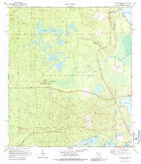
~ Juniper Springs FL topo map, 1:24000 scale, 7.5 X 7.5 Minute, Historical, 1972, updated 1987
Juniper Springs, Florida, USGS topographic map dated 1972.
Includes geographic coordinates (latitude and longitude). This topographic map is suitable for hiking, camping, and exploring, or framing it as a wall map.
Printed on-demand using high resolution imagery, on heavy weight and acid free paper, or alternatively on a variety of synthetic materials.
Topos available on paper, Waterproof, Poly, or Tyvek. Usually shipping rolled, unless combined with other folded maps in one order.
- Product Number: USGS-5625284
- Free digital map download (high-resolution, GeoPDF): Juniper Springs, Florida (file size: 13 MB)
- Map Size: please refer to the dimensions of the GeoPDF map above
- Weight (paper map): ca. 55 grams
- Map Type: POD USGS Topographic Map
- Map Series: HTMC
- Map Verison: Historical
- Cell ID: 22950
- Scan ID: 346869
- Imprint Year: 1987
- Woodland Tint: Yes
- Aerial Photo Year: 1969
- Field Check Year: 1972
- Datum: NAD27
- Map Projection: Transverse Mercator
- Map published by United States Geological Survey
- Map Language: English
- Scanner Resolution: 600 dpi
- Map Cell Name: Juniper Springs
- Grid size: 7.5 X 7.5 Minute
- Date on map: 1972
- Map Scale: 1:24000
- Geographical region: Florida, United States
Neighboring Maps:
All neighboring USGS topo maps are available for sale online at a variety of scales.
Spatial coverage:
Topo map Juniper Springs, Florida, covers the geographical area associated the following places:
- Wildcat Lake - Silver Glen Springs Run - Ocala Pond - Juniper Prairie Wilderness - Sweetwater Springs - Crooked Sapling Pond - Thomas Forbes Grant - Ocala National Forest - F M Arredondo Grant - Juniper Prairie - Juniper Springs - Fern Hammock Springs - George I F Clarke Grant - Silver Glen Springs Recreation Area - Wildcat Lake Boat Ramp - Morman Branch - Ocala National Recreation Trail - Pats Island - Silver Glen Springs - Long Cemetery - Juniper Creek Boating Site - Juniper Springs Campground - Juniper Springs Recreation Area
- Map Area ID: AREA29.2529.125-81.75-81.625
- Northwest corner Lat/Long code: USGSNW29.25-81.75
- Northeast corner Lat/Long code: USGSNE29.25-81.625
- Southwest corner Lat/Long code: USGSSW29.125-81.75
- Southeast corner Lat/Long code: USGSSE29.125-81.625
- Northern map edge Latitude: 29.25
- Southern map edge Latitude: 29.125
- Western map edge Longitude: -81.75
- Eastern map edge Longitude: -81.625


