
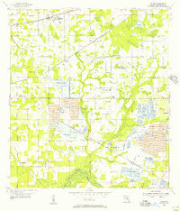
~ Dover FL topo map, 1:24000 scale, 7.5 X 7.5 Minute, Historical, 1955, updated 1956
Dover, Florida, USGS topographic map dated 1955.
Includes geographic coordinates (latitude and longitude). This topographic map is suitable for hiking, camping, and exploring, or framing it as a wall map.
Printed on-demand using high resolution imagery, on heavy weight and acid free paper, or alternatively on a variety of synthetic materials.
Topos available on paper, Waterproof, Poly, or Tyvek. Usually shipping rolled, unless combined with other folded maps in one order.
- Product Number: USGS-5623614
- Free digital map download (high-resolution, GeoPDF): Dover, Florida (file size: 9 MB)
- Map Size: please refer to the dimensions of the GeoPDF map above
- Weight (paper map): ca. 55 grams
- Map Type: POD USGS Topographic Map
- Map Series: HTMC
- Map Verison: Historical
- Cell ID: 12691
- Scan ID: 345873
- Imprint Year: 1956
- Woodland Tint: Yes
- Visual Version Number: 1
- Aerial Photo Year: 1947
- Survey Year: 1955
- Datum: NAD27
- Map Projection: Polyconic
- Map published by United States Geological Survey
- Map Language: English
- Scanner Resolution: 600 dpi
- Map Cell Name: Dover
- Grid size: 7.5 X 7.5 Minute
- Date on map: 1955
- Map Scale: 1:24000
- Geographical region: Florida, United States
Neighboring Maps:
All neighboring USGS topo maps are available for sale online at a variety of scales.
Spatial coverage:
Topo map Dover, Florida, covers the geographical area associated the following places:
- Mulrennan Estates - Martin - Legends Pass - Marlyn Manor - Brandon East - Rosswell Acres - Margaline Gardens - Hinson Acres - Delarua - Wellington - Simmons Estate - McGraths Orangettes - Par Meadows - Connell Groves - Puntkins Place - Sidney Highlands - Ranch Road Groves - Lone Oak Haven - Reynoso - Doris Coats Acres - McGrath - Sugarloaf Ridge - Daniels Acres - West Plant City - Saint Cloud Reserve - Walden Lake - Buckhorn Oaks - Whitlock - Stone Hollow - Buckhorn Hills - Durant Trails - East Brandon Heights - Lucas Manor - Dover Woods - Citrus Oaks - Dovewood Estates - Pineapple Hill - Aarons Place - Thompson Oaks - Raulerson Estates North - Tague Acres - Country Breeze Estates - Buckhorn Preserve - Drakes Place - Brown Estates - Sytsma Estates - Eastgate Extension - Bent Tree - Heritage Crest - Sydney Crossings - Canterbury Oaks - Sierra Estates - Lone Oak Grove - Charles Donnel Acres - Buckhorn Springs Mobile Villa - Messick Acres - Oakwood Forest - C T Lewis Acres - Isabel Estates - Brock Acres - Allens Cove - Abbey Grove - Sexton Acres - Harder Oaks - Cinnamon Trace - Brandon Ridgeland - Bloomingdale - Somerset - Hidden Forest East - Popago Estates - Tract 80 Estates - Indian Trails - Welch Creek Acres - Miller Woods - Lehman Acres - Durant - Little Alafia Creek Estates - Gwaltney Acres - Taft - Pleasant Grove Acres - Beattys Corner - Shupard Estates - Buckhorn Golf Club Estates - Durant Oaks - Toole Place - Dunham Mobile Home Park - Stone Hedge - Jerrys - Medley Manor - Park Meadow - Hopewell Gardens - Wetherington Oaks - Pine Dale Estates - West Plant City Farms - Pleasant Grove - Leonard - Salem Church Estates - Oaklane Estates - The Cove - Wallace Road Acres
- Map Area ID: AREA2827.875-82.25-82.125
- Northwest corner Lat/Long code: USGSNW28-82.25
- Northeast corner Lat/Long code: USGSNE28-82.125
- Southwest corner Lat/Long code: USGSSW27.875-82.25
- Southeast corner Lat/Long code: USGSSE27.875-82.125
- Northern map edge Latitude: 28
- Southern map edge Latitude: 27.875
- Western map edge Longitude: -82.25
- Eastern map edge Longitude: -82.125


