
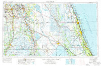
~ Fort Pierce FL topo map, 1:250000 scale, 1 X 2 Degree, Historical, 1956, updated 1976
Fort Pierce, Florida, USGS topographic map dated 1956.
Includes geographic coordinates (latitude and longitude). This topographic map is suitable for hiking, camping, and exploring, or framing it as a wall map.
Printed on-demand using high resolution imagery, on heavy weight and acid free paper, or alternatively on a variety of synthetic materials.
Topos available on paper, Waterproof, Poly, or Tyvek. Usually shipping rolled, unless combined with other folded maps in one order.
- Product Number: USGS-5621718
- Free digital map download (high-resolution, GeoPDF): Fort Pierce, Florida (file size: 20 MB)
- Map Size: please refer to the dimensions of the GeoPDF map above
- Weight (paper map): ca. 55 grams
- Map Type: POD USGS Topographic Map
- Map Series: HTMC
- Map Verison: Historical
- Cell ID: 68784
- Scan ID: 346312
- Imprint Year: 1976
- Woodland Tint: Yes
- Aerial Photo Year: 1972
- Edit Year: 1972
- Datum: Unstated
- Map Projection: Transverse Mercator
- Map published by United States Geological Survey
- Map published by: Military, Other
- Map Language: English
- Scanner Resolution: 600 dpi
- Map Cell Name: Fort Pierce
- Grid size: 1 X 2 Degree
- Date on map: 1956
- Map Scale: 1:250000
- Geographical region: Florida, United States
Neighboring Maps:
All neighboring USGS topo maps are available for sale online at a variety of scales.
Spatial coverage:
Topo map Fort Pierce, Florida, covers the geographical area associated the following places:
- Grant - The Highlander Mobile Home Court - Dinner Lake Haven Mobile Home - Florida Palm Mobile Park - Open Gate Trailer Park - Green Bay - Pinelake Gardens Estates - West Lake Wales - Highland Lakes - Placid Lakes - Cypress Acres Mobile Home Park - Waveland - Oakview Lakes Mobile Home Park - Ona - Port Sewall - Fort Meade - El Capitan Mobile Home Park - Bartow Mobile Home Park - Sweetwater - Sunrise Trailer Park - Selph's Mobile Home Village - The Oasis at Zolfo Springs Mobile Home Park - Paradise Lakes Mobile Home Park - Florida Ridge - Peace River Shores - Indiantown - Countryside Mobile Home Park - Pebbledale - Azteca Mobile Home Park - Lakewood Park - Hammock Mobile Estates Mobile Home Park - Sweeneys Mobile Home Park - Avon Park - Southfort - Four Acres Mobile Home Park - Winterset Shores Estates Mobile Home Park - Oak Gardens Mobile Home Park - Lake Shipp Heights - Childs - Fuller Heights - Tanglewood Mobile Home Park - Golden Gate - Avon Park Lakes - Lake Redwater Mobile Home Park - Ranchland Mobile Home Park - Ridgewood - Seminole Shores - Seminole Mobile Park - Floridana Beach - Buckhead Ridge - Baird - Orchid - Prairie Junction - Villa del Sol Mobile Home Park - Pierce - Francis I Mobile Estates - Pedaler's Pond Mobile Home Park - Valkaria - Marcy - Basswood Estates - Big Oak Mobile Home Park - Brighton - Vero Mobile Home Park - Stephen's Winter Resort Mobile Home Park - Bairs Den - High Ridge Mobile Park - Sarasota Colony - Eldred - Journey End Mobile Home Park - Rifle Range Mobile Home - Rainbow Trailer Park - Arundel - Sunland Gardens - Gomez - Ewell - Coachland Court Mobile Home Park - Lake of the Hills - Rio - Little Gator Park Mobile Home Park - Reflections on Silver Lake Mobile Home Park - Plains - Port Saint Lucie - Hicoria - Shady Rest Mobile Home Park - River Bend Mobile Home Park - Lake Clinch Manor Mobile Home Park - Ocean Breeze Park - Connersville - Highland City - Hickory Lake Estates Mobile Home Park - Lily - Highlands Park Estates - Vantage Oaks Mobile Home Park - Dun Runnin Park Mobile Home Park - Tangelo Village Mobile Home Park - Town and Country Mobile Home Park - West Frostproof - Royster - Southern Comfort Mobile Home Park - Glidden Park
- Map Area ID: AREA2827-82-80
- Northwest corner Lat/Long code: USGSNW28-82
- Northeast corner Lat/Long code: USGSNE28-80
- Southwest corner Lat/Long code: USGSSW27-82
- Southeast corner Lat/Long code: USGSSE27-80
- Northern map edge Latitude: 28
- Southern map edge Latitude: 27
- Western map edge Longitude: -82
- Eastern map edge Longitude: -80


