
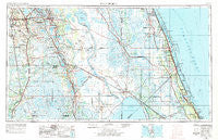
~ Fort Pierce FL topo map, 1:250000 scale, 1 X 2 Degree, Historical, 1956, updated 1984
Fort Pierce, Florida, USGS topographic map dated 1956.
Includes geographic coordinates (latitude and longitude). This topographic map is suitable for hiking, camping, and exploring, or framing it as a wall map.
Printed on-demand using high resolution imagery, on heavy weight and acid free paper, or alternatively on a variety of synthetic materials.
Topos available on paper, Waterproof, Poly, or Tyvek. Usually shipping rolled, unless combined with other folded maps in one order.
- Product Number: USGS-5621716
- Free digital map download (high-resolution, GeoPDF): Fort Pierce, Florida (file size: 19 MB)
- Map Size: please refer to the dimensions of the GeoPDF map above
- Weight (paper map): ca. 55 grams
- Map Type: POD USGS Topographic Map
- Map Series: HTMC
- Map Verison: Historical
- Cell ID: 68784
- Scan ID: 346311
- Imprint Year: 1984
- Woodland Tint: Yes
- Aerial Photo Year: 1972
- Edit Year: 1972
- Datum: Unstated
- Map Projection: Transverse Mercator
- Map published by: Military, Other
- Map Language: English
- Scanner Resolution: 600 dpi
- Map Cell Name: Fort Pierce
- Grid size: 1 X 2 Degree
- Date on map: 1956
- Map Scale: 1:250000
- Geographical region: Florida, United States
Neighboring Maps:
All neighboring USGS topo maps are available for sale online at a variety of scales.
Spatial coverage:
Topo map Fort Pierce, Florida, covers the geographical area associated the following places:
- Cypress Gardens - Leisure Village Mobile Home Park - Avon Park - Pinelake Village Mobile Home Park - Sunland Gardens - Laurel Mobile Home Park - Green Acres Mobile Home Park - Alpine - Fort Drum - Winter Beach - Ridge Trailer Park - Hendersons Mobile Home Park - Babson Park - Highland Wheel Estates Mobile Home Park - Parker Island - Citrus Valley Mobile Home Estates - Anglevillas - Sunshine Mobile Manor - Sewall's Point - Bartow Mobile Home Park - Washburn Mobile Home Park - Gifford - Fort Green Springs - Doans Mobile Home Park - Katies Korner Mobile Home Park - Port Salerno - Barcola - Pebbledale - Bobs Landing Mobile Home Park - Mountain Lake Station - Lake Gardens Mobile Home Park - Medulla - Bennetts Mobile Home Park - The Palms Mobile Home Park - Sweetwater Mobile Home Park - Lake Glenada Mobile Home Park - Collins Park Estates - Tryon - Cana - Hagners Trailer Park - Sebring Village Mobile Home Park - Reedy Haven Trailer Park - Kissimmee River Fishing Resort Mobile Home Park - Carlton - Southern Pines Recreational Vehicle Park - Tall Pines Mobile Home Community - Indian Lake Estates - Wild Island - Fuller Heights - River Bend Mobile Home Park - Roux Quarters - Eden - Emily Park Mobile Home Park - Mayberry's Mobile Home Park - Grape Hammock Mobile Home Park - Arcadia - Holiday Mobile Home Park - Vero Palm Estates - Winter Haven Mobile Home Park - Manley Mobile Home Park - Hillcrest Heights - Indian River Shores - Riomar - Istokpoga - Torpey Oaks Mobile Home Park - Grace Mobile Home Park - Basinger - Oak Terrace - Big Oak Mobile Home Park - Lily - Bear Hollow - Oslo - Woodlawn Manor Mobile Home Park - Grove Shores Mobile Colony - Arcadia Village Adult Mobile Home Community - Lakeland Highlands - Bessemer - Cubitis - Marina Cove Mobile Home Park - Shady Rest Mobile Home Park - Hebel Acres Mobile Home Park - Bluefield - Cypress Knee Cove Mobile Home Park - Paradise Lakes Mobile Home Park - Palm Villa Mobile Home Park - Lake Redwater Mobile Home Park - Sunset Mobile Home Park - Southern Pines Mobile Home Resort - Sarasota Colony - Yeehaw Junction - Lakeside Village Mobile Home Park - Rifle Range Mobile Home - Neilson - Lighthouse Point - J B's Mobile Home Park - J and W Trailer Park - Zolfo Springs - Reed Mobile Home Park - Fort Ogden - Valencia Family Mobile Home Park
- Map Area ID: AREA2827-82-80
- Northwest corner Lat/Long code: USGSNW28-82
- Northeast corner Lat/Long code: USGSNE28-80
- Southwest corner Lat/Long code: USGSSW27-82
- Southeast corner Lat/Long code: USGSSE27-80
- Northern map edge Latitude: 28
- Southern map edge Latitude: 27
- Western map edge Longitude: -82
- Eastern map edge Longitude: -80


