
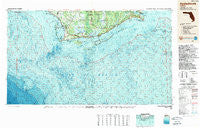
~ Apalachicola FL topo map, 1:250000 scale, 1 X 2 Degree, Historical, 1988, updated 1988
Apalachicola, Florida, USGS topographic map dated 1988.
Includes geographic coordinates (latitude and longitude). This topographic map is suitable for hiking, camping, and exploring, or framing it as a wall map.
Printed on-demand using high resolution imagery, on heavy weight and acid free paper, or alternatively on a variety of synthetic materials.
Topos available on paper, Waterproof, Poly, or Tyvek. Usually shipping rolled, unless combined with other folded maps in one order.
- Product Number: USGS-5621686
- Free digital map download (high-resolution, GeoPDF): Apalachicola, Florida (file size: 28 MB)
- Map Size: please refer to the dimensions of the GeoPDF map above
- Weight (paper map): ca. 55 grams
- Map Type: POD USGS Topographic Map
- Map Series: HTMC
- Map Verison: Historical
- Cell ID: 68648
- Scan ID: 344952
- Imprint Year: 1988
- Woodland Tint: Yes
- Edit Year: 1988
- Datum: NAD27
- Map Projection: Universal Transverse Mercator
- Map published by United States Geological Survey
- Map Language: English
- Scanner Resolution: 600 dpi
- Map Cell Name: Apalachicola
- Grid size: 1 X 2 Degree
- Date on map: 1988
- Map Scale: 1:250000
- Geographical region: Florida, United States
Neighboring Maps:
All neighboring USGS topo maps are available for sale online at a variety of scales.
Spatial coverage:
Topo map Apalachicola, Florida, covers the geographical area associated the following places:
- Carrabelle - Franklin - Pine Log - Milltown - Sun N Sand Beaches - McIntyre - Nine Mile - Highland View - Magnolia Bluffs - Yent Place - Surf - Saint Teresa - Big Blackjack Landing - Apalachicola - Two Mile - Ward Ridge - White City - Beverly - Green Point - Port Saint Joe - Eleven Mile - Carrabelle Beach - Mexico Beach - Niles - High Bluff - Beacon Hill - Davis Beach - Bay City - Oak Grove - Lanark Village - Achackwaithle (historical) - Indian Pass - Carrabelle Lighthouse - Odena - Overstreet - Fort Gadsden - Brickyard - Eastpoint - Hays Place - Ekanachatte (historical) - Creels - Saint George Island - Saint Joe Beach - Tilton
- Map Area ID: AREA3029-86-84
- Northwest corner Lat/Long code: USGSNW30-86
- Northeast corner Lat/Long code: USGSNE30-84
- Southwest corner Lat/Long code: USGSSW29-86
- Southeast corner Lat/Long code: USGSSE29-84
- Northern map edge Latitude: 30
- Southern map edge Latitude: 29
- Western map edge Longitude: -86
- Eastern map edge Longitude: -84


