
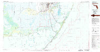
~ Homestead FL topo map, 1:100000 scale, 30 X 60 Minute, Historical, 1982, updated 1983
Homestead, Florida, USGS topographic map dated 1982.
Includes geographic coordinates (latitude and longitude). This topographic map is suitable for hiking, camping, and exploring, or framing it as a wall map.
Printed on-demand using high resolution imagery, on heavy weight and acid free paper, or alternatively on a variety of synthetic materials.
Topos available on paper, Waterproof, Poly, or Tyvek. Usually shipping rolled, unless combined with other folded maps in one order.
- Product Number: USGS-5621602
- Free digital map download (high-resolution, GeoPDF): Homestead, Florida (file size: 16 MB)
- Map Size: please refer to the dimensions of the GeoPDF map above
- Weight (paper map): ca. 55 grams
- Map Type: POD USGS Topographic Map
- Map Series: HTMC
- Map Verison: Historical
- Cell ID: 67678
- Scan ID: 346694
- Imprint Year: 1983
- Woodland Tint: Yes
- Aerial Photo Year: 1980
- Edit Year: 1982
- Datum: NAD27
- Map Projection: Universal Transverse Mercator
- Map published by United States Geological Survey
- Map Language: English
- Scanner Resolution: 600 dpi
- Map Cell Name: Homestead
- Grid size: 30 X 60 Minute
- Date on map: 1982
- Map Scale: 1:100000
- Geographical region: Florida, United States
Neighboring Maps:
All neighboring USGS topo maps are available for sale online at a variety of scales.
Spatial coverage:
Topo map Homestead, Florida, covers the geographical area associated the following places:
- Sponge Rocks - Rock Harbor Marina East Mobile Home Park - Tavernier - Newport - Sunset Point - Paradise Point Mobile Home Park - Grayvik - Gateway West - Leisure City - North Key Largo - Riptide Trailer Park - Garden Cove - Cutter Bank - Dynamite Docks - Thompson - Homestead - Gateway Estates - Boardwalk Mobile Home Park - Goldcoaster Mobile Home Park - Flamingo - Jewfish - Florida City - Gold Key - Travel Trailer Town - Four Seasons Mobile Home Park - Key Largo - Coastal Waterway Park Mobile Home Park - Anglers Park - Rock Harbor - Manatee Cove Mobile Home Park - The Board Walk Mobile Home Park - Homestead Trailer Park - Carysfort Yacht Harbor - Aquarius Mobile Home Park - Key Largo Park - Homestead Trailer Park - Islandia
- Map Area ID: AREA25.525-81-80
- Northwest corner Lat/Long code: USGSNW25.5-81
- Northeast corner Lat/Long code: USGSNE25.5-80
- Southwest corner Lat/Long code: USGSSW25-81
- Southeast corner Lat/Long code: USGSSE25-80
- Northern map edge Latitude: 25.5
- Southern map edge Latitude: 25
- Western map edge Longitude: -81
- Eastern map edge Longitude: -80


