
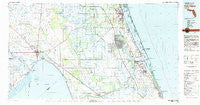
~ Fort Pierce FL topo map, 1:100000 scale, 30 X 60 Minute, Historical, 1981, updated 1982
Fort Pierce, Florida, USGS topographic map dated 1981.
Includes geographic coordinates (latitude and longitude). This topographic map is suitable for hiking, camping, and exploring, or framing it as a wall map.
Printed on-demand using high resolution imagery, on heavy weight and acid free paper, or alternatively on a variety of synthetic materials.
Topos available on paper, Waterproof, Poly, or Tyvek. Usually shipping rolled, unless combined with other folded maps in one order.
- Product Number: USGS-5621592
- Free digital map download (high-resolution, GeoPDF): Fort Pierce, Florida (file size: 24 MB)
- Map Size: please refer to the dimensions of the GeoPDF map above
- Weight (paper map): ca. 55 grams
- Map Type: POD USGS Topographic Map
- Map Series: HTMC
- Map Verison: Historical
- Cell ID: 67538
- Scan ID: 346306
- Imprint Year: 1982
- Woodland Tint: Yes
- Aerial Photo Year: 1977
- Edit Year: 1981
- Datum: NAD27
- Map Projection: Universal Transverse Mercator
- Map published by United States Geological Survey
- Map Language: English
- Scanner Resolution: 600 dpi
- Map Cell Name: Fort Pierce
- Grid size: 30 X 60 Minute
- Date on map: 1981
- Map Scale: 1:100000
- Geographical region: Florida, United States
Neighboring Maps:
All neighboring USGS topo maps are available for sale online at a variety of scales.
Spatial coverage:
Topo map Fort Pierce, Florida, covers the geographical area associated the following places:
- Whispering Pines - Snug Harbor - Marcy - Indianwood Manufactured Housing Community - Vantage Oaks Mobile Home Park - Hebel Acres Mobile Home Park - Sunland Gardens - Carlton - Whispering Creek Village Mobile Home Park - Bennetts Mobile Home Park - Sherman - Tall Pines Mobile Home Community - Glidden Park - Globe Mobile Home Park - Lighthouse Point - Anglevillas - Fort Pierce - Holiday Mobile Home Park - Tropical Park - Basswood Estates - Okeechobee - Tangelo Village Mobile Home Park - Ankona - Harmony Heights - Eden - Sewall's Point - Towering Pines Mobile Home Park - Cypress Quarters - Seabreeze Mobile Manor - Sheltras Trailer Park - Jensen Beach - Four Acres Mobile Home Park - Eighth Street Mobile Home Park - Skyline Heights - Zana - Open Gate Trailer Park - Fort Pierce Shores - Collins Park Estates - Hilolo - Jims Place Mobile Home Park - Florida Palm Mobile Park - Kissimmee River Fishing Resort Mobile Home Park - Gomez - Seminole Village Mobile Home Park - Indian River Estates - Gator Park Mobile Home Park - Sunshine Mobile Manor - Twin Rivers Mobile Home Park - Journey End Mobile Home Park - Gloria Park Mobile Home Park - Georges Lucky Seven Mobile Home Park Number 1 - Pine Ridge Park Mobile Home Park - Johnsons Trailer Park - Glen Oaks Mobile Home Park - Palm Vista Mobile Ranch - Hobe Sound - Stuart - Pinelake Village Mobile Home Park - Up the Grove Beach - Pinelake Gardens Estates - Waveland - Rio - Eagle Island - Casablanca Mobile Home Park - Enchanted Forest Mobile Home Park - Spanish Lakes Riverfront Mobile Home Park - Fruita - Jacobs Trailer Park - Salerno Trailer Park - Cortez Estates - Saint Lucie - Azteca Mobile Home Park - Town and Country Mobile Home Park - Port Sewall - Leisure Village Mobile Home Park - Bessemer - Villa Margaret Trailer Park - Chapman Trailer Park - La Fiesta Trailer Park - Lone Oak Mobile Home Park - Hobe Village Mobile Home Park - Golden Gate - Port Saint Lucie - Mildred - Emily Park Mobile Home Park - Lighthouse Park Mobile Home Park - Mayberry's Mobile Home Park - Barber Quarters - Ocean Breeze Park - 46th Avenue Villas Mobile Home Park - Seminole Shores - Shady Oaks Mobile Home Park - Paradise Park - Windsong Mobile Village - Walton - La Buona Vita Mobile Home Park - J and W Trailer Park - Ackel Mobile Home Estates - Seminole Mobile Park - Katies Korner Mobile Home Park
- Map Area ID: AREA27.527-81-80
- Northwest corner Lat/Long code: USGSNW27.5-81
- Northeast corner Lat/Long code: USGSNE27.5-80
- Southwest corner Lat/Long code: USGSSW27-81
- Southeast corner Lat/Long code: USGSSE27-80
- Northern map edge Latitude: 27.5
- Southern map edge Latitude: 27
- Western map edge Longitude: -81
- Eastern map edge Longitude: -80


