
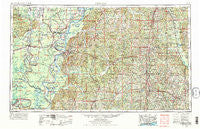
~ Natchez MS topo map, 1:250000 scale, 1 X 2 Degree, Historical, 1953, updated 1975
Natchez, Mississippi, USGS topographic map dated 1953.
Includes geographic coordinates (latitude and longitude). This topographic map is suitable for hiking, camping, and exploring, or framing it as a wall map.
Printed on-demand using high resolution imagery, on heavy weight and acid free paper, or alternatively on a variety of synthetic materials.
Topos available on paper, Waterproof, Poly, or Tyvek. Usually shipping rolled, unless combined with other folded maps in one order.
- Product Number: USGS-5599106
- Free digital map download (high-resolution, GeoPDF): Natchez, Mississippi (file size: 24 MB)
- Map Size: please refer to the dimensions of the GeoPDF map above
- Weight (paper map): ca. 55 grams
- Map Type: POD USGS Topographic Map
- Map Series: HTMC
- Map Verison: Historical
- Cell ID: 68929
- Scan ID: 337277
- Imprint Year: 1975
- Woodland Tint: Yes
- Visual Version Number: 1
- Aerial Photo Year: 1972
- Edit Year: 1973
- Field Check Year: 1953
- Datum: Unstated
- Map Projection: Transverse Mercator
- Map published by: Military, Other
- Map Language: English
- Scanner Resolution: 600 dpi
- Map Cell Name: Natchez
- Grid size: 1 X 2 Degree
- Date on map: 1953
- Map Scale: 1:250000
- Geographical region: Mississippi, United States
Neighboring Maps:
All neighboring USGS topo maps are available for sale online at a variety of scales.
Spatial coverage:
Topo map Natchez, Mississippi, covers the geographical area associated the following places:
- Monroe - Wilkinson - Archie - Washington - Hopewell - Wellman - Cannonsburg - Locust Ridge - Lismore - Osceola - Pricedale - White Hall (historical) - Cam - Denhart - Harrisville - Lamberts Store - Harriston - Flowery Mound (historical) - Georgetown - Book - Hazlehurst - Rosetta - Union Church - Dick - Trinity - Dentville - Kinnaird (historical) - Arnot - Green Meadow - Enon - Quaid - Saint Elmo - Wildwood - Burnell - Natchez Under the Hill (historical) - Luckett (historical) - Summit - Martin - Centreville - Tilton - Huntley (historical) - Ashwood - Argo - Barlow - Hoodtown - Conn - Greenville - Davo - Dunbarton - Carthage - Carto - Blue Hill - Spring Ridge - Cadillac - Merrick - Cooter Point - Montgomery - Fenwick - Dixie (historical) - Melton - Morgantown - Craig Landing - Wallace Ridge - Extension - Copeland Landing - Delhoste - Conerly - U and I Landing - Armagh - Serena - Fort Adams - Sardis - Gum Ridge (historical) - Hiram - McElveen - Fair Oak Springs - Wanilla - Anchor Landing - Spokane - Woolworth - Ashley - Hermanville - Liberty - Brabston (historical) - Hebron - Azucena - Gibson Landing - Whitaker - Red Lick - Sicily Island - Simonds - Lexie - Hooker - Black River (historical) - Elkhorn - Buena Vista (historical) - Turtle Lake (historical) - Red Fish - Hedgeland Landing - Allen
- Map Area ID: AREA3231-92-90
- Northwest corner Lat/Long code: USGSNW32-92
- Northeast corner Lat/Long code: USGSNE32-90
- Southwest corner Lat/Long code: USGSSW31-92
- Southeast corner Lat/Long code: USGSSE31-90
- Northern map edge Latitude: 32
- Southern map edge Latitude: 31
- Western map edge Longitude: -92
- Eastern map edge Longitude: -90


