
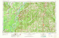
~ Natchez MS topo map, 1:250000 scale, 1 X 2 Degree, Historical, 1953, updated 1966
Natchez, Mississippi, USGS topographic map dated 1953.
Includes geographic coordinates (latitude and longitude). This topographic map is suitable for hiking, camping, and exploring, or framing it as a wall map.
Printed on-demand using high resolution imagery, on heavy weight and acid free paper, or alternatively on a variety of synthetic materials.
Topos available on paper, Waterproof, Poly, or Tyvek. Usually shipping rolled, unless combined with other folded maps in one order.
- Product Number: USGS-5599102
- Free digital map download (high-resolution, GeoPDF): Natchez, Mississippi (file size: 22 MB)
- Map Size: please refer to the dimensions of the GeoPDF map above
- Weight (paper map): ca. 55 grams
- Map Type: POD USGS Topographic Map
- Map Series: HTMC
- Map Verison: Historical
- Cell ID: 68929
- Scan ID: 337275
- Imprint Year: 1966
- Woodland Tint: Yes
- Aerial Photo Year: 1953
- Edit Year: 1965
- Datum: Unstated
- Map Projection: Transverse Mercator
- Map published by United States Army Corps of Engineers
- Map published by United States Army
- Map Language: English
- Scanner Resolution: 600 dpi
- Map Cell Name: Natchez
- Grid size: 1 X 2 Degree
- Date on map: 1953
- Map Scale: 1:250000
- Geographical region: Mississippi, United States
Neighboring Maps:
All neighboring USGS topo maps are available for sale online at a variety of scales.
Spatial coverage:
Topo map Natchez, Mississippi, covers the geographical area associated the following places:
- Shucktown - East Lincoln - Ruth - Caseyville - Borodino - Deane (historical) - Berwick - Trinity - Mixon - Morgantown - Athlone - Linden (historical) - Peyton - Rafn - Parhams - Selma - Highland - Monterey - Hawthorne - Bridgeport - Davo - Tilton - Schley - Hunter Landing - Warnicott (historical) - Hustler - Pattona (historical) - Barland - Cross Keys - Hedgeland - Walters - Hoodtown - Westside - Goldman Landing - Homochitto - Alphenia Landing - Gillsburg - Zetus - Fayette - Vaughn - Alcorn - Tatum - Flowery Mound (historical) - Kirkville - Dunbarton - Canebrake - Liberty - Pitts - Glading - Mayna - Vidalia - Oxford - Wilsonia - Brabston (historical) - Jennings - Utility - Crosby - Robinwood - Johnstons Station - Holmesville - Woodville - Glancy - Clayton - Possum Corner - Bougere - Crimea - Center Point - Thayer - Big A Plenty Landing - Emerald - Coars Springs (historical) - Red Lick - Union Point - Hartman - Ballina - Gloster - Busy Corner - Lamberts Store - Bogue Chitto - Alton (historical) - Mount Olive - Duty - Burtonton (historical) - Red Fish - Conn - New Hope - Meadville - Point Breeze - Pattison - Darrington - Babington (historical) - Natchez - Lorman - Lee Bayou - Enterprise - Shaw - Beauregard - Tryus - Bowerton - Chevey Chase
- Map Area ID: AREA3231-92-90
- Northwest corner Lat/Long code: USGSNW32-92
- Northeast corner Lat/Long code: USGSNE32-90
- Southwest corner Lat/Long code: USGSSW31-92
- Southeast corner Lat/Long code: USGSSE31-90
- Northern map edge Latitude: 32
- Southern map edge Latitude: 31
- Western map edge Longitude: -92
- Eastern map edge Longitude: -90


