
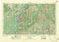
~ Natchez MS topo map, 1:250000 scale, 1 X 2 Degree, Historical, 1956, updated 1956
Natchez, Mississippi, USGS topographic map dated 1956.
Includes geographic coordinates (latitude and longitude). This topographic map is suitable for hiking, camping, and exploring, or framing it as a wall map.
Printed on-demand using high resolution imagery, on heavy weight and acid free paper, or alternatively on a variety of synthetic materials.
Topos available on paper, Waterproof, Poly, or Tyvek. Usually shipping rolled, unless combined with other folded maps in one order.
- Product Number: USGS-5599098
- Free digital map download (high-resolution, GeoPDF): Natchez, Mississippi (file size: 30 MB)
- Map Size: please refer to the dimensions of the GeoPDF map above
- Weight (paper map): ca. 55 grams
- Map Type: POD USGS Topographic Map
- Map Series: HTMC
- Map Verison: Historical
- Cell ID: 68929
- Scan ID: 337273
- Imprint Year: 1956
- Woodland Tint: Yes
- Aerial Photo Year: 1952
- Field Check Year: 1953
- Datum: Unstated
- Map Projection: Transverse Mercator
- Map published by United States Army Corps of Engineers
- Map published by United States Army
- Map Language: English
- Scanner Resolution: 600 dpi
- Map Cell Name: Natchez
- Grid size: 1 X 2 Degree
- Date on map: 1956
- Map Scale: 1:250000
- Geographical region: Mississippi, United States
Neighboring Maps:
All neighboring USGS topo maps are available for sale online at a variety of scales.
Spatial coverage:
Topo map Natchez, Mississippi, covers the geographical area associated the following places:
- Stephens (historical) - Armagh - Wildwood - Carlos - Athlone - Moreauville - Saint Joseph - New Hope - Ashland - Smyrna - Dick - White Cap - Shelby (historical) - Linden (historical) - Bristers Store - East Lincoln - Cool Coosa - Arnot - Bruinsburg - Fernwood - Verna - Rosella - Bristerville - Delhoste - Wildsville - Alcorn - Newtonia - Saukum - Lorman - Glading - Gretna Green - Capell - Dennis Crossroads - Hamburg - Anna - Stanton - Laneheart - Doloroso - Alphenia Landing - Franklin - Highland - Gibson Landing - Peoria - Kinnaird (historical) - Ustane - Tillman - Elam - Lucerna (historical) - Osyka - Locust Ridge - Barcelona - Oxford - Hunter Landing - Borodino - Pine Ridge - Hopewell - Crescent Landing - Pricedale - Melton - Sontag - North Fork (historical) - OK Landing - McComb - Wallace Ridge - Donegal - Spring Ridge - Argent - Osceola - Homochitto - Book - Irene - Centreville - Barlow - Meadville - Ruby - White Apple - Gillsburg - Ariel - Ashland - Whitaker - Martins Landing - Deane (historical) - Tatum - Maitland Landing - Utility - Dixie (historical) - Peck - Spokane - Monroe - Hardscrabble (historical) - Coaler (historical) - Simonds - Knoxo - Old Georgetown (historical) - Saughy (historical) - Stacy - Minorca - Gallman - Carto - Pleasant Hill
- Map Area ID: AREA3231-92-90
- Northwest corner Lat/Long code: USGSNW32-92
- Northeast corner Lat/Long code: USGSNE32-90
- Southwest corner Lat/Long code: USGSSW31-92
- Southeast corner Lat/Long code: USGSSE31-90
- Northern map edge Latitude: 32
- Southern map edge Latitude: 31
- Western map edge Longitude: -92
- Eastern map edge Longitude: -90


