
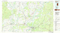
~ Natchez MS topo map, 1:100000 scale, 30 X 60 Minute, Historical, 1984, updated 1984
Natchez, Mississippi, USGS topographic map dated 1984.
Includes geographic coordinates (latitude and longitude). This topographic map is suitable for hiking, camping, and exploring, or framing it as a wall map.
Printed on-demand using high resolution imagery, on heavy weight and acid free paper, or alternatively on a variety of synthetic materials.
Topos available on paper, Waterproof, Poly, or Tyvek. Usually shipping rolled, unless combined with other folded maps in one order.
- Product Number: USGS-5599028
- Free digital map download (high-resolution, GeoPDF): Natchez, Mississippi (file size: 21 MB)
- Map Size: please refer to the dimensions of the GeoPDF map above
- Weight (paper map): ca. 55 grams
- Map Type: POD USGS Topographic Map
- Map Series: HTMC
- Map Verison: Historical
- Cell ID: 68029
- Scan ID: 337237
- Imprint Year: 1984
- Woodland Tint: Yes
- Aerial Photo Year: 1979
- Edit Year: 1984
- Datum: NAD27
- Map Projection: Universal Transverse Mercator
- Planimetric: Yes
- Map published by United States Geological Survey
- Map Language: English
- Scanner Resolution: 600 dpi
- Map Cell Name: Natchez
- Grid size: 30 X 60 Minute
- Date on map: 1984
- Map Scale: 1:100000
- Geographical region: Mississippi, United States
Neighboring Maps:
All neighboring USGS topo maps are available for sale online at a variety of scales.
Spatial coverage:
Topo map Natchez, Mississippi, covers the geographical area associated the following places:
- Kirks Landing - Foster - Manifest - Minorca - Hunter Landing - Denmark Landing - Hedgeland - Stampley - Hedgeland Landing - Avondale - Lavacco - Azucena - Frogmore - Gretna Green - Troy - Justina - Natchez Under the Hill (historical) - Rosefield - Alphenia Landing - Goldman - Greenville - Harriston - Locust Ridge - Shankstown (historical) - Barcelona - Crimea - Mayhew Landing - Ferriday - White Hall (historical) - Carthage - Wilsonia - Olympic Landing - Linwood - Oak Dale Landing - Eltringham Landing - Saughy (historical) - Foules - Anchor Landing - Cooters Landing - Buena Vista (historical) - McNair - Peck - West Ferriday - Selma - Argent - Elkhorn - Spokane - Leesdale - Cool Coosa - Uniontown (historical) - Wallace Ridge - Richland - Westside - Saint John - Denhart - Sycamore - Sicily Island - North Fork (historical) - Phoenix (historical) - Lismore - Hamburg - Gibson Landing - Natchez - Moro - Jones Landing - Red Gum - Security - Orange - Luckett (historical) - Black River (historical) - Quaid - Bullitt Bayou - Scotland (historical) - Ashland - Gum Ridge (historical) - Hawthorne - Alcorn - Turtle Lake (historical) - Webb - Ballina - Maitland - Cannonsburg - OK Landing - Elam - Mayflower - Dunbarton - Maitland Landing - Fenwick - Waterproof - Goldman Landing - Leland - Wisner - Clifton - Enterprise - Copeland Landing - Holly Grove - Aimwell - Saint Genevieve - Chamblee - Russum
- Map Area ID: AREA3231.5-92-91
- Northwest corner Lat/Long code: USGSNW32-92
- Northeast corner Lat/Long code: USGSNE32-91
- Southwest corner Lat/Long code: USGSSW31.5-92
- Southeast corner Lat/Long code: USGSSE31.5-91
- Northern map edge Latitude: 32
- Southern map edge Latitude: 31.5
- Western map edge Longitude: -92
- Eastern map edge Longitude: -91


