
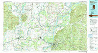
~ Natchez MS topo map, 1:100000 scale, 30 X 60 Minute, Historical, 1991, updated 1992
Natchez, Mississippi, USGS topographic map dated 1991.
Includes geographic coordinates (latitude and longitude). This topographic map is suitable for hiking, camping, and exploring, or framing it as a wall map.
Printed on-demand using high resolution imagery, on heavy weight and acid free paper, or alternatively on a variety of synthetic materials.
Topos available on paper, Waterproof, Poly, or Tyvek. Usually shipping rolled, unless combined with other folded maps in one order.
- Product Number: USGS-5599026
- Free digital map download (high-resolution, GeoPDF): Natchez, Mississippi (file size: 29 MB)
- Map Size: please refer to the dimensions of the GeoPDF map above
- Weight (paper map): ca. 55 grams
- Map Type: POD USGS Topographic Map
- Map Series: HTMC
- Map Verison: Historical
- Cell ID: 68029
- Scan ID: 337236
- Imprint Year: 1992
- Woodland Tint: Yes
- Aerial Photo Year: 1986
- Edit Year: 1991
- Datum: NAD27
- Map Projection: Universal Transverse Mercator
- Map published by United States Geological Survey
- Map Language: English
- Scanner Resolution: 600 dpi
- Map Cell Name: Natchez
- Grid size: 30 X 60 Minute
- Date on map: 1991
- Map Scale: 1:100000
- Geographical region: Mississippi, United States
Neighboring Maps:
All neighboring USGS topo maps are available for sale online at a variety of scales.
Spatial coverage:
Topo map Natchez, Mississippi, covers the geographical area associated the following places:
- Walters - U and I Landing - Phoenix (historical) - Holly Grove - Springfield (historical) - Sherwood - Hunter Landing - Chevey Chase - Washington - Mayflower - Mileston Forks - Big A Plenty Landing - Kirks Landing - Turtle Lake (historical) - Elam - Roxie - Stanton - Alcorn - Saint John - Orange - Taconey - Hawthorne - Manifest - Frogmore - Uniontown (historical) - Metropolis - Martins Landing - Alphenia Landing - Leesdale - Waterproof - Wilsonia - Ballina - Gretna Green - Sycamore - Argent - Lucerna (historical) - Stonington - Fenwick - Lake Bruin - Lismore - Foules - Troy - Stacy - Deane (historical) - Wildsville - Vidalia - Natchez - Security - Cool Coosa - Hedgeland - Omega - McNair - Avondale - Maitland - Black River (historical) - Gibson Landing - Scotland (historical) - Wallace Ridge - Dunbarton - Rodney - Crimea - Millerfield (historical) - Bullitt Bayou - Natchez Under the Hill (historical) - Chamblee - Duty - Craig Landing - Webb - Johnsville - Moro - Justina - Red Gum - Mayhew Landing - Cross Keys - North Fork (historical) - Maitland Landing - Norris Springs - Cooters Landing - Melton - Cadillac - Greenville - Wildwood - Spokane - Highland - Anna - Saughy (historical) - Saint Catherine - West Ferriday - Westside - Clifton - Ashland - Willetts - Four Forks - Utility - Bruinsburg - Lavacco - Dixie (historical) - Wisner - Cranfield - OK Landing
- Map Area ID: AREA3231.5-92-91
- Northwest corner Lat/Long code: USGSNW32-92
- Northeast corner Lat/Long code: USGSNE32-91
- Southwest corner Lat/Long code: USGSSW31.5-92
- Southeast corner Lat/Long code: USGSSE31.5-91
- Northern map edge Latitude: 32
- Southern map edge Latitude: 31.5
- Western map edge Longitude: -92
- Eastern map edge Longitude: -91


