
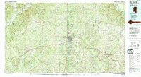
~ McComb MS topo map, 1:100000 scale, 30 X 60 Minute, Historical, 1994, updated 1994
McComb, Mississippi, USGS topographic map dated 1994.
Includes geographic coordinates (latitude and longitude). This topographic map is suitable for hiking, camping, and exploring, or framing it as a wall map.
Printed on-demand using high resolution imagery, on heavy weight and acid free paper, or alternatively on a variety of synthetic materials.
Topos available on paper, Waterproof, Poly, or Tyvek. Usually shipping rolled, unless combined with other folded maps in one order.
- Product Number: USGS-5599016
- Free digital map download (high-resolution, GeoPDF): McComb, Mississippi (file size: 31 MB)
- Map Size: please refer to the dimensions of the GeoPDF map above
- Weight (paper map): ca. 55 grams
- Map Type: POD USGS Topographic Map
- Map Series: HTMC
- Map Verison: Historical
- Cell ID: 67926
- Scan ID: 337231
- Imprint Year: 1994
- Woodland Tint: Yes
- Aerial Photo Year: 1992
- Edit Year: 1994
- Datum: NAD27
- Map Projection: Universal Transverse Mercator
- Map published by United States Geological Survey
- Map Language: English
- Scanner Resolution: 600 dpi
- Map Cell Name: McComb
- Grid size: 30 X 60 Minute
- Date on map: 1994
- Map Scale: 1:100000
- Geographical region: Mississippi, United States
Neighboring Maps:
All neighboring USGS topo maps are available for sale online at a variety of scales.
Spatial coverage:
Topo map McComb, Mississippi, covers the geographical area associated the following places:
- Barto - Conerly - Johnstons Station - Ariel - Bacots - Bristerville - Dillon - Lexie - Jayess - Topeka - Fernwood - Berwick - O'Neil - Beechwood - Center Point - Dinan - Emerald - Lamberts Store - Little Springs - Blueberry Hill - Progress - Thompson - Tilton - Leggett - Hebron - Bristers Store - Wilkinson - McElveen - Simmonsville - Monroe - Jennings - Zion Hill - Summit - Bewelcome - Mount Olive - Vaughts - Verna - Bridges - Compromise - New Holmesville (historical) - Enterprise - Homochitto - Magnolia - Topisaw - Peoria - Conerby (historical) - Bude - Simonds - Smithdale - Huron - Arlington - Glading - Dykes Crossing - Darbun - Davo - Suffolk - Dick - Terrys Creek - Holmesville - Capell - Kirkville - China Grove - Enon - Quinlivan - Martin - Mesa - Mixon - Ruth - Kirklin - White Cap - Wellman - Brookside - Olio - Oxford - Gillsburg - Flowers - Pricedale - McComb - Tylertown - East Lincoln - West Lincoln - Sartinville - Osyka - Salem - Norfield - Meadville - Knoxo - Stella - East Fork - Lehr - Stephens (historical) - Smithburg - Bogue Chitto - Auburn - Kioto - Hustler - Rushing - Babington (historical) - Kokomo - Beardens
- Map Area ID: AREA31.531-91-90
- Northwest corner Lat/Long code: USGSNW31.5-91
- Northeast corner Lat/Long code: USGSNE31.5-90
- Southwest corner Lat/Long code: USGSSW31-91
- Southeast corner Lat/Long code: USGSSE31-90
- Northern map edge Latitude: 31.5
- Southern map edge Latitude: 31
- Western map edge Longitude: -91
- Eastern map edge Longitude: -90


