
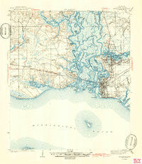
~ Pascagoula MS topo map, 1:62500 scale, 15 X 15 Minute, Historical, 1943
Pascagoula, Mississippi, USGS topographic map dated 1943.
Includes geographic coordinates (latitude and longitude). This topographic map is suitable for hiking, camping, and exploring, or framing it as a wall map.
Printed on-demand using high resolution imagery, on heavy weight and acid free paper, or alternatively on a variety of synthetic materials.
Topos available on paper, Waterproof, Poly, or Tyvek. Usually shipping rolled, unless combined with other folded maps in one order.
- Product Number: USGS-5598664
- Free digital map download (high-resolution, GeoPDF): Pascagoula, Mississippi (file size: 7 MB)
- Map Size: please refer to the dimensions of the GeoPDF map above
- Weight (paper map): ca. 55 grams
- Map Type: POD USGS Topographic Map
- Map Series: HTMC
- Map Verison: Historical
- Cell ID: 60789
- Scan ID: 337033
- Survey Year: 1941
- Datum: NAD27
- Map Projection: Polyconic
- Map published by United States Geological Survey
- Map published by United States Department of War
- Map Language: English
- Scanner Resolution: 600 dpi
- Map Cell Name: Pascagoula
- Grid size: 15 X 15 Minute
- Date on map: 1943
- Map Scale: 1:62500
- Geographical region: Mississippi, United States
Neighboring Maps:
All neighboring USGS topo maps are available for sale online at a variety of scales.
Spatial coverage:
Topo map Pascagoula, Mississippi, covers the geographical area associated the following places:
- Moss Point - Highland Park Mobile Home Park - Bluff Creek Mobile Home Park - Olive Pine Mobile Home Park - South Pascagoula - Hickory Hills - Ferguson's Mobile Home Park - East Pascagoula - Fort Bayou (historical) - Sawmill Pointe - Anchor Trailer Park - Isle of Pines Mobile Home Village - East Side - Burroughs Mobile Park - Browns Mobile Park - Ford - Longhorn Mobile Park - Martin Bluff - Fountainebleau - Beachwood Mobile Home Park - Krebs Mobile Park - Isle of Pines Mobile Home Park - Omas Pine Mobile Home Park - Fairchilds Mobile Home Park - Gautier - Baker Mobile Home Park - Gulf Breeze Mobile Home Park - Escatawpa - Simmons Mobile Home Park - Hilda - Lewis Mobile Park - Coast Meadows Mobile Home Park - Pascagoula
- Map Area ID: AREA30.530.25-88.75-88.5
- Northwest corner Lat/Long code: USGSNW30.5-88.75
- Northeast corner Lat/Long code: USGSNE30.5-88.5
- Southwest corner Lat/Long code: USGSSW30.25-88.75
- Southeast corner Lat/Long code: USGSSE30.25-88.5
- Northern map edge Latitude: 30.5
- Southern map edge Latitude: 30.25
- Western map edge Longitude: -88.75
- Eastern map edge Longitude: -88.5


