
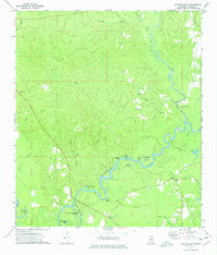
~ Leakesville SW MS topo map, 1:24000 scale, 7.5 X 7.5 Minute, Historical, 1973, updated 1975
Leakesville SW, Mississippi, USGS topographic map dated 1973.
Includes geographic coordinates (latitude and longitude). This topographic map is suitable for hiking, camping, and exploring, or framing it as a wall map.
Printed on-demand using high resolution imagery, on heavy weight and acid free paper, or alternatively on a variety of synthetic materials.
Topos available on paper, Waterproof, Poly, or Tyvek. Usually shipping rolled, unless combined with other folded maps in one order.
- Product Number: USGS-5596650
- Free digital map download (high-resolution, GeoPDF): Leakesville SW, Mississippi (file size: 10 MB)
- Map Size: please refer to the dimensions of the GeoPDF map above
- Weight (paper map): ca. 55 grams
- Map Type: POD USGS Topographic Map
- Map Series: HTMC
- Map Verison: Historical
- Cell ID: 25234
- Scan ID: 335979
- Imprint Year: 1975
- Woodland Tint: Yes
- Aerial Photo Year: 1971
- Field Check Year: 1973
- Datum: NAD27
- Map Projection: Transverse Mercator
- Map published by United States Geological Survey
- Map Language: English
- Scanner Resolution: 600 dpi
- Map Cell Name: Leakesville SW
- Grid size: 7.5 X 7.5 Minute
- Date on map: 1973
- Map Scale: 1:24000
- Geographical region: Mississippi, United States
Neighboring Maps:
All neighboring USGS topo maps are available for sale online at a variety of scales.
Spatial coverage:
Topo map Leakesville SW, Mississippi, covers the geographical area associated the following places:
- Roberts Lake - Lige Branch - Brushy Creek - McManus Post Office (historical) - Pine Grove Church - Conn Creek - Hogan Creek - Dressler Hammond Dead River - Cowans Dead River - Coward Place Cemetery - Grace Church - Midway Church - Roberts Bluff - Skinner Creek - Green Lodge Cemetery - Long Lake - Mount Zion Church (historical) - Spring Lake - Denny Branch - Round Lake - Williams Cemetery - McInnis Creek - Big Creek - Hammill Creek - Pine Grove Cemetery - Shell Bluff - Little Creek - Bear Pond Branch - Redbird Lake - Congregational Church - Rattlesnake Lake - Colemans Ferry (historical) - Ard Branch - Vernal School (historical) - Evans Creek - New Hope Church (historical) - Miller Bridge - Colonel Merrill Lake - Gatling Creek
- Map Area ID: AREA31.12531-88.75-88.625
- Northwest corner Lat/Long code: USGSNW31.125-88.75
- Northeast corner Lat/Long code: USGSNE31.125-88.625
- Southwest corner Lat/Long code: USGSSW31-88.75
- Southeast corner Lat/Long code: USGSSE31-88.625
- Northern map edge Latitude: 31.125
- Southern map edge Latitude: 31
- Western map edge Longitude: -88.75
- Eastern map edge Longitude: -88.625


