
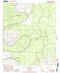
~ Waverly SE LA topo map, 1:24000 scale, 7.5 X 7.5 Minute, Historical, 1987, updated 1987
Waverly SE, Louisiana, USGS topographic map dated 1987.
Includes geographic coordinates (latitude and longitude). This topographic map is suitable for hiking, camping, and exploring, or framing it as a wall map.
Printed on-demand using high resolution imagery, on heavy weight and acid free paper, or alternatively on a variety of synthetic materials.
Topos available on paper, Waterproof, Poly, or Tyvek. Usually shipping rolled, unless combined with other folded maps in one order.
- Product Number: USGS-5592310
- Free digital map download (high-resolution, GeoPDF): Waverly SE, Louisiana (file size: 9 MB)
- Map Size: please refer to the dimensions of the GeoPDF map above
- Weight (paper map): ca. 55 grams
- Map Type: POD USGS Topographic Map
- Map Series: HTMC
- Map Verison: Historical
- Cell ID: 47802
- Scan ID: 333507
- Imprint Year: 1987
- Woodland Tint: Yes
- Visual Version Number: 1
- Aerial Photo Year: 1982
- Edit Year: 1987
- Field Check Year: 1984
- Datum: NAD27
- Map Projection: Lambert Conformal Conic
- Provisional map: Yes
- Map published by United States Geological Survey
- Map Language: English
- Scanner Resolution: 600 dpi
- Map Cell Name: Waverly SE
- Grid size: 7.5 X 7.5 Minute
- Date on map: 1987
- Map Scale: 1:24000
- Geographical region: Louisiana, United States
Neighboring Maps:
All neighboring USGS topo maps are available for sale online at a variety of scales.
Spatial coverage:
Topo map Waverly SE, Louisiana, covers the geographical area associated the following places:
- Cross Bayou - Strong Lake - Little Rainey Lake - Big Rainey Lake - Little Bear Lake - Mothiglam Bayou - Ward Two - Parish Governing Authority District 2 - Dunlap Lake - Mack Bayou - Horseshoe Lake - Judd Bayou - Wolf Lake - Lower Mississippi Region - 2-digit Hydrologic Unit Code - 08 - Bear Wallow - Spring Bayou - Rainey Brake - Johns Bayou
- Map Area ID: AREA32.37532.25-91.375-91.25
- Northwest corner Lat/Long code: USGSNW32.375-91.375
- Northeast corner Lat/Long code: USGSNE32.375-91.25
- Southwest corner Lat/Long code: USGSSW32.25-91.375
- Southeast corner Lat/Long code: USGSSE32.25-91.25
- Northern map edge Latitude: 32.375
- Southern map edge Latitude: 32.25
- Western map edge Longitude: -91.375
- Eastern map edge Longitude: -91.25


