
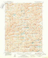
~ Spring Valley NE topo map, 1:62500 scale, 15 X 15 Minute, Historical, 1950
Spring Valley, Nebraska, USGS topographic map dated 1950.
Includes geographic coordinates (latitude and longitude). This topographic map is suitable for hiking, camping, and exploring, or framing it as a wall map.
Printed on-demand using high resolution imagery, on heavy weight and acid free paper, or alternatively on a variety of synthetic materials.
Topos available on paper, Waterproof, Poly, or Tyvek. Usually shipping rolled, unless combined with other folded maps in one order.
- Product Number: USGS-5563570
- Free digital map download (high-resolution, GeoPDF): Spring Valley, Nebraska (file size: 10 MB)
- Map Size: please refer to the dimensions of the GeoPDF map above
- Weight (paper map): ca. 55 grams
- Map Type: POD USGS Topographic Map
- Map Series: HTMC
- Map Verison: Historical
- Cell ID: 62868
- Scan ID: 317668
- Woodland Tint: Yes
- Aerial Photo Year: 1946
- Field Check Year: 1948
- Datum: NAD27
- Map Projection: Polyconic
- Map published by United States Geological Survey
- Map Language: English
- Scanner Resolution: 600 dpi
- Map Cell Name: Spring Valley
- Grid size: 15 X 15 Minute
- Date on map: 1950
- Map Scale: 1:62500
- Geographical region: Nebraska, United States
Neighboring Maps:
All neighboring USGS topo maps are available for sale online at a variety of scales.
Spatial coverage:
Topo map Spring Valley, Nebraska, covers the geographical area associated the following places:
- Hardy Valley - Anderson Lake - Whitman Election Precinct - Split Lake - Buchfinck Ranch - Hyannis Election Precinct - Egan Ranch - Williams Lake - Long Valley - Brooking Valley - Grant County - Winnie Valley - Rothwell Ranch - Dyer Ranch - School Number 8 - Kramer Ranch - Cogill Lake - Flats Place - Egan Lake - Long Lake - School Number 2 - Haney Lake - Vinton Ranch - Bunner Lake - Beem Lake - Sheperd Ranch - Wright Ranch - Pratt Valley - Muskrat Lake - Wheelock Ranch - Spring Valley Lake - Bunner Ranch - Spring Valley - Round Lake - Claw Hammer Lake - Snyder Valley - Drake Valley - Pratt Lake - Scotty Lake - Rose Hill School - Handlin Valley - Moran Lake - Simpson Ranch - Hebbert Ranch - Rothwell Lake - Middle Valley - Round Valley - Heigh Valley - Negro Lake - Farrar Ranch - Green Lake - Vinton Valley - Lynch Circle Ranch - Rothwell Valley
- Map Area ID: AREA4241.75-101.75-101.5
- Northwest corner Lat/Long code: USGSNW42-101.75
- Northeast corner Lat/Long code: USGSNE42-101.5
- Southwest corner Lat/Long code: USGSSW41.75-101.75
- Southeast corner Lat/Long code: USGSSE41.75-101.5
- Northern map edge Latitude: 42
- Southern map edge Latitude: 41.75
- Western map edge Longitude: -101.75
- Eastern map edge Longitude: -101.5


