
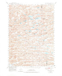
~ Spade Ranch NE topo map, 1:62500 scale, 15 X 15 Minute, Historical, 1948, updated 1976
Spade Ranch, Nebraska, USGS topographic map dated 1948.
Includes geographic coordinates (latitude and longitude). This topographic map is suitable for hiking, camping, and exploring, or framing it as a wall map.
Printed on-demand using high resolution imagery, on heavy weight and acid free paper, or alternatively on a variety of synthetic materials.
Topos available on paper, Waterproof, Poly, or Tyvek. Usually shipping rolled, unless combined with other folded maps in one order.
- Product Number: USGS-5563560
- Free digital map download (high-resolution, GeoPDF): Spade Ranch, Nebraska (file size: 10 MB)
- Map Size: please refer to the dimensions of the GeoPDF map above
- Weight (paper map): ca. 55 grams
- Map Type: POD USGS Topographic Map
- Map Series: HTMC
- Map Verison: Historical
- Cell ID: 62808
- Scan ID: 317663
- Imprint Year: 1976
- Aerial Photo Year: 1946
- Field Check Year: 1948
- Datum: NAD27
- Map Projection: Polyconic
- Map published by United States Geological Survey
- Map Language: English
- Scanner Resolution: 600 dpi
- Map Cell Name: Spade Ranch
- Grid size: 15 X 15 Minute
- Date on map: 1948
- Map Scale: 1:62500
- Geographical region: Nebraska, United States
Neighboring Maps:
All neighboring USGS topo maps are available for sale online at a variety of scales.
Spatial coverage:
Topo map Spade Ranch, Nebraska, covers the geographical area associated the following places:
- School Number 131 (historical) - Wolf Hill - Osborne Lake - Clear Lake - Big Dad Lake - Sandoz Lake - Piper Ranch - Spade School - Round Lake - Spring Lake Airport - Hill Crest School (historical) - Billys Lake - Kern Lake - E Strasburger Ranch - School Number 166 - Big Hill Valley - Wolford Valley - Strasburger Ranch - Rucker Lake - Dolly Warden Lake - Minnich Lake - Miller Lake - East Kinney Lake - Brighton Valley - Big Hill - H Glasgow South Ranch - Anderson Lake - A Hamilton Ranch - Hupp Lake - School Number 143 (historical) - Short Lake - Halverson Ranch - Middle Osborne Lake - E Hamilton Ranch - Petes Lake - Spring Lake - Spring Lake Ranch - J Sandoz Ranch - School Number 89 (historical) - Jacobs Lake - Argo Hill - Sandoz Ranch - Hamilton Ranch - Lloyd Hill - Auker Lake - Bean Soup Lake - Goose Lake - Morton Hill - Chicken Lake - T Strasburger Ranch - McAlister Lake - Mari Sandoz State Historical Marker - Big Hill Valley - Smith Lake - F Sandoz Ranch - West Osborne Lake - Keys Lake - Dukat Ranch - School Number 134 (historical) - Neilson Ranch - Gem Valley - Kinney Lake - School Number 166 (historical) - School Number 161 (historical) - Home Lake - Mooney Ranch - N Hamilton Ranch - Peterson Ranch - C Hamilton Ranch - Willow Valley - Highland Flats - Mari Sandoz Museum - F Sandoz Ranch - Kinkaid Election Precinct (historical) - Star Lake - Hebbert Lake - Spade Ranch - P Strasburger Ranch - Dorsey Ranch - D Hamilton Ranch - White Valley - Bunger Lake - School Number 158 (historical)
- Map Area ID: AREA42.542.25-102.25-102
- Northwest corner Lat/Long code: USGSNW42.5-102.25
- Northeast corner Lat/Long code: USGSNE42.5-102
- Southwest corner Lat/Long code: USGSSW42.25-102.25
- Southeast corner Lat/Long code: USGSSE42.25-102
- Northern map edge Latitude: 42.5
- Southern map edge Latitude: 42.25
- Western map edge Longitude: -102.25
- Eastern map edge Longitude: -102


