
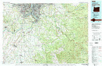
~ Oregon City OR topo map, 1:100000 scale, 30 X 60 Minute, Historical, 1982, updated 1983
Oregon City, Oregon, USGS topographic map dated 1982.
Includes geographic coordinates (latitude and longitude). This topographic map is suitable for hiking, camping, and exploring, or framing it as a wall map.
Printed on-demand using high resolution imagery, on heavy weight and acid free paper, or alternatively on a variety of synthetic materials.
Topos available on paper, Waterproof, Poly, or Tyvek. Usually shipping rolled, unless combined with other folded maps in one order.
- Product Number: USGS-5545778
- Free digital map download (high-resolution, GeoPDF): Oregon City, Oregon (file size: 32 MB)
- Map Size: please refer to the dimensions of the GeoPDF map above
- Weight (paper map): ca. 55 grams
- Map Type: POD USGS Topographic Map
- Map Series: HTMC
- Map Verison: Historical
- Cell ID: 68097
- Scan ID: 283112
- Imprint Year: 1983
- Woodland Tint: Yes
- Aerial Photo Year: 1981
- Edit Year: 1982
- Datum: NAD27
- Map Projection: Universal Transverse Mercator
- Map published by United States Geological Survey
- Map Language: English
- Scanner Resolution: 600 dpi
- Map Cell Name: Oregon City
- Grid size: 30 X 60 Minute
- Date on map: 1982
- Map Scale: 1:100000
- Geographical region: Oregon, United States
Neighboring Maps:
All neighboring USGS topo maps are available for sale online at a variety of scales.
Spatial coverage:
Topo map Oregon City, Oregon, covers the geographical area associated the following places:
- Westmoreland - Stringtown (historical) - Scotts Mills - Eastmoreland - Hillsview - Johnson City - Aims - Aurora - Springbrook - Timber Grove - Cherryville - Multnomah - Englewood - Happy Valley - Hoodview - Bethany - Sellwood - Tobias - Kelso - Oak Grove - Canemah - Milwaukie - Kinton - Whitford - Ripplebrook - Currinsville - Sunnyside - Jean - West Portland - Chemawa - Ardenwald - Fishers Corner - Aloha - Cook - Rural Dell - Carver - Old Colton - Shady Dell - Christie (historical) - Hazel Green - Damascus - Belle Passi (historical) - Dominic (historical) - Bonita - Deep Creek (historical) - Bertha (historical) - Bryant - Firwood - Mount Angel - Tualatin - Sunset - North Howell - Laurel - King City - Donald - Central Point - Ladd Hill - Mulino - Upper Highland - Pleasant Home - Sandy - Lakewood - Woodstock - Butteville - Hillsdale - Maplewood - Labish Center - Capitol Hill - Gladstone - Hazeldale - Farmington - Glencullen - West Woodburn - Marylhurst - Carson Heights - South Portland (historical) - Oaklawn - Elliott Prairie - Battin - Jennings Lodge - Six Corners - Dodge - Clackamas - Colton - Chehalem - Clackamas Heights - Logan - Robinwood - Estacada - New Era - Mount Pleasant - Wilhoit - Willamette - South Lake Oswego - Barlow - Park Place - Brooks - Hubbard - Dunthorpe - Kellogg Park
- Map Area ID: AREA45.545-123-122
- Northwest corner Lat/Long code: USGSNW45.5-123
- Northeast corner Lat/Long code: USGSNE45.5-122
- Southwest corner Lat/Long code: USGSSW45-123
- Southeast corner Lat/Long code: USGSSE45-122
- Northern map edge Latitude: 45.5
- Southern map edge Latitude: 45
- Western map edge Longitude: -123
- Eastern map edge Longitude: -122


