
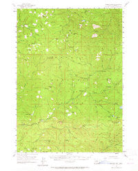
~ Quartz Mtn OR topo map, 1:62500 scale, 15 X 15 Minute, Historical, 1955, updated 1965
Quartz Mtn, Oregon, USGS topographic map dated 1955.
Includes geographic coordinates (latitude and longitude). This topographic map is suitable for hiking, camping, and exploring, or framing it as a wall map.
Printed on-demand using high resolution imagery, on heavy weight and acid free paper, or alternatively on a variety of synthetic materials.
Topos available on paper, Waterproof, Poly, or Tyvek. Usually shipping rolled, unless combined with other folded maps in one order.
- Product Number: USGS-5545252
- Free digital map download (high-resolution, GeoPDF): Quartz Mtn, Oregon (file size: 9 MB)
- Map Size: please refer to the dimensions of the GeoPDF map above
- Weight (paper map): ca. 55 grams
- Map Type: POD USGS Topographic Map
- Map Series: HTMC
- Map Verison: Historical
- Cell ID: 61380
- Scan ID: 282820
- Imprint Year: 1965
- Woodland Tint: Yes
- Aerial Photo Year: 1953
- Field Check Year: 1955
- Datum: NAD27
- Map Projection: Polyconic
- Map published by United States Geological Survey
- Map Language: English
- Scanner Resolution: 600 dpi
- Map Cell Name: Quartz Mountain
- Grid size: 15 X 15 Minute
- Date on map: 1955
- Map Scale: 1:62500
- Geographical region: Oregon, United States
Neighboring Maps:
All neighboring USGS topo maps are available for sale online at a variety of scales.
Spatial coverage:
Topo map Quartz Mtn, Oregon, covers the geographical area associated the following places:
- Harpham Lake - Jackson Creek Trail - Pinnacle Creek - Cliff Lake - Bow Creek - Lake in the Woods Boat Ramp - South Umpqua Guard Station - Buckhead Trail - Dead Cow Lake - South Umpqua Falls Recreation Site - Buck Prairie - Skillet Creek - French Creek - Skimmerhorn Trailhead - West Fork Skimmerhorn Creek - Jade Camp - Hemlock Meadows Recreation Site - Coyote Creek - Little Fish Lake - Grasshopper Mountain - Lonewoman Creek - Skimmerhorn Recreation Site - Hemlock Lake - Emerson Ranch - Last Creek - Ash Creek - Deer Lick Falls - Buckeye Creek - Acker Rock - Clover Falls - Cow Prairie - Doehead Mountain - Buckhead Mountain - Fish Lake - Silver Creek - BVD Trail - Grasshopper Meadow - Twin Lake Creek - Fish Lake Creek - Birdseye Camp - Snowbird Shelter - Junction Spring - Sheep Prairie - Mink Creek - Alligator Lake - Mud Lake - Skookum Chuck Camp (historical) - Twin Lakes Mountain - Twin Lakes Trail - Hemlock Creek - Camp Comfort Recreation Site - Skimmerhorn Creek - Umpqua National Forest - Fish Lake Recreation Site - Carmen Lake - Emile Trail - Big Twin Lakes Campground - Flat Rock - Lake in the Woods Recreation Site - Hemlock Meadows Dam - Camp Coffee Pot - Hemlock Lake Boat Ramp - South Limpy Prairie - Little Black Rock - Buckhead Mountain Campground - Black Rock Fork - Junction Creek - Buster Spring Shelter - Coffeepot Creek - Castor Lake - Youtlkut Pillars - Boze Creek - Hemlock Lake Recreation Site - Twin Lakes Recreation Site - South Umpqua Experimental Forest - Prong Creek - Raven Rock - Acker Divide Trail - Times Square Rock - Horse Prairie - Cavitt Mountain - Fish Lake Trailhead - Horn Prairie - Hemlock Falls - Copeland Creek Trail - Beaver Swamp Recreation Site - Andraieff Meadows - Quartz Mountain Guard Station - Erlebach Ranch - Camp Vena - Flagstone Peak - Flagstone Creek - Clover Butte - Boze Shelter - Beaver Swamp Trailhead - Yellow Jacket Glade - Buckeye Lake - Cinderella Spring - Emerson Creek - Limpy Mountain
- Map Area ID: AREA43.2543-122.75-122.5
- Northwest corner Lat/Long code: USGSNW43.25-122.75
- Northeast corner Lat/Long code: USGSNE43.25-122.5
- Southwest corner Lat/Long code: USGSSW43-122.75
- Southeast corner Lat/Long code: USGSSE43-122.5
- Northern map edge Latitude: 43.25
- Southern map edge Latitude: 43
- Western map edge Longitude: -122.75
- Eastern map edge Longitude: -122.5


