
~ Pearsoll Peak OR topo map, 1:62500 scale, 15 X 15 Minute, Historical, 1954, updated 1980
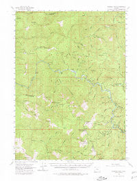
Pearsoll Peak, Oregon, USGS topographic map dated 1954.
Includes geographic coordinates (latitude and longitude). This topographic map is suitable for hiking, camping, and exploring, or framing it as a wall map.
Printed on-demand using high resolution imagery, on heavy weight and acid free paper, or alternatively on a variety of synthetic materials.
Topos available on paper, Waterproof, Poly, or Tyvek. Usually shipping rolled, unless combined with other folded maps in one order.
- Product Number: USGS-5545190
- Free digital map download (high-resolution, GeoPDF): Pearsoll Peak, Oregon (file size: 10 MB)
- Map Size: please refer to the dimensions of the GeoPDF map above
- Weight (paper map): ca. 55 grams
- Map Type: POD USGS Topographic Map
- Map Series: HTMC
- Map Verison: Historical
- Cell ID: 60833
- Scan ID: 282779
- Imprint Year: 1980
- Woodland Tint: Yes
- Aerial Photo Year: 1952
- Field Check Year: 1954
- Datum: NAD27
- Map Projection: Polyconic
- Map published by United States Geological Survey
- Map Language: English
- Scanner Resolution: 600 dpi
- Map Cell Name: Pearsoll Peak
- Grid size: 15 X 15 Minute
- Date on map: 1954
- Map Scale: 1:62500
- Geographical region: Oregon, United States
Neighboring Maps:
All neighboring USGS topo maps are available for sale online at a variety of scales.
Spatial coverage:
Topo map Pearsoll Peak, Oregon, covers the geographical area associated the following places:
- Tincup Peak - South Bend Mountain - Store Gulch Recreation Site - Little Todd Creek - Pearsoll Mine - Florence Creek - Todd Creek - Marsh Creek - West Ridge Camp - Robertson Mine - Horse Flat - Box Canyon Creek - Deadman Bar - Albright Mine (historical) - Chinaman Hat - Labrador Creek - Nobles House - Slide Creek - East Fork Pine Creek - Lightning Creek - Sluice Creek - Hayward Peak - Kalmiopsis Wilderness - Nome Creek - West Fork Rancherie Creek - Brushy Bar - Sourdough Flat - Eagles Nest Mine - Pine Flat - Yukon Creek - Twin Cedars Creek - O'Conner Creek - Dasher Meadow - Mount Billingslea - Bills Gulch - Chance Creek - Uncle Sam Mine - Old Glory Mine - Castle Rock - Dick Creek - Trail Canyon - Lake Creek - Babyfoot Creek - York Creek - Cedar Camp - Taggarts Bar - Soldier Creek - Golden Eagle Mine (historical) - Johnson Butte - Chrome King Mine - West Fork Pine Creek - Granite Creek - Miller Creek - The Wild - Eagle Mountain - Gold Basin - Hayden Creek - Crater Creek - Eureka Mine - Little Silver Creek Lake - Dorr Canyon - Store Gulch - Chetco Pass Creek - Heather Creek - Upper Chetco Trail - Little Silver Creek - Silver Prairie - Pine Creek - South Fork Silver Creek - Chetco Bar - Clear Creek - Miami Bar Boat Launch - Polar Spring - Sulphur Creek - Pine Creek Shelter (historical) - Oak Flat - Cox Mine (historical) - Klondike Creek - Weaver Ranch (historical) - Green Wall - Bowser Mine - Pearsoll Peak - Middle Bald Prairie - Salmon Creek - Deep Gorge Mine - Bald Mountain Prairie - Siskiyou National Forest - Fall Creek Copper Mine - Phillips Creek - Hall Cabin - Mud Springs - Dailey Creek - Pearsoll Creek - Miami Bar - Briggs Creek - School Flat - Panther Bar - Illinois River Trail - Rawhide Creek - Oak Flat Creek
- Map Area ID: AREA42.542.25-124-123.75
- Northwest corner Lat/Long code: USGSNW42.5-124
- Northeast corner Lat/Long code: USGSNE42.5-123.75
- Southwest corner Lat/Long code: USGSSW42.25-124
- Southeast corner Lat/Long code: USGSSE42.25-123.75
- Northern map edge Latitude: 42.5
- Southern map edge Latitude: 42.25
- Western map edge Longitude: -124
- Eastern map edge Longitude: -123.75


