
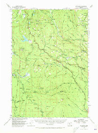
~ Mt Wilson OR topo map, 1:62500 scale, 15 X 15 Minute, Historical, 1956, updated 1973
Mt Wilson, Oregon, USGS topographic map dated 1956.
Includes geographic coordinates (latitude and longitude). This topographic map is suitable for hiking, camping, and exploring, or framing it as a wall map.
Printed on-demand using high resolution imagery, on heavy weight and acid free paper, or alternatively on a variety of synthetic materials.
Topos available on paper, Waterproof, Poly, or Tyvek. Usually shipping rolled, unless combined with other folded maps in one order.
- Product Number: USGS-5545144
- Free digital map download (high-resolution, GeoPDF): Mt Wilson, Oregon (file size: 7 MB)
- Map Size: please refer to the dimensions of the GeoPDF map above
- Weight (paper map): ca. 55 grams
- Map Type: POD USGS Topographic Map
- Map Series: HTMC
- Map Verison: Historical
- Cell ID: 58146
- Scan ID: 282752
- Imprint Year: 1973
- Woodland Tint: Yes
- Aerial Photo Year: 1954
- Field Check Year: 1956
- Datum: NAD27
- Map Projection: Polyconic
- Map published by United States Geological Survey
- Map Language: English
- Scanner Resolution: 600 dpi
- Map Cell Name: Mount Wilson
- Grid size: 15 X 15 Minute
- Date on map: 1956
- Map Scale: 1:62500
- Geographical region: Oregon, United States
Neighboring Maps:
All neighboring USGS topo maps are available for sale online at a variety of scales.
Spatial coverage:
Topo map Mt Wilson, Oregon, covers the geographical area associated the following places:
- McQuinn Strip (historical) - Dahl Pine - Beaver Butte Creek - Deadman Spring - Mount Wilson Trail - Cedar Burn Camp - Faith Spring Forest Camp - Frog Lake Buttes - Little Boulder Way Trail - Bonney Meadows Trail - Wilson Cove Trail - Persia M Robinson Natural Area - Deep Creek - Clear Creek Crossing Recreation Site - Cedar Creek - Crane Creek Forest Camp - Keeps Mill (historical) - Charity Spring - Swamp Creek - Driveway Trail - Bonney Creek - Frog Creek Trail - Wilson Creek Driveway - Rocky Point - Clear Lake - Alkali Quarry - Mount Wilson - Dobry Point - Wapinitia Pass - Twin Lakes - Cold Springs Creek - Forest Creek Recreation Site - Little Crater Lake Recreation Site - Little Boulder Lake - Elk Creek - Catalpa Lake - Wilson Creek - Wasco Dam - Red Wolf Pass - Buckskin Butte - Boulder Creek - Frog Lake - Faith Spring - Swamp Creek Hidden Meadows Trail - Green Lake Creek - Frog Creek Ditch - Ghost Creek - White River Station Recreation Site - Cedar Swamp Creek - Post Point - Clear Creek Ditch - Abbot Pass - Frog Lake Recreation Site - Barlow Creek Recreation Site - Green Lakes Quarry - Wests Butte - Clear Lake Campground Boat Launch - East West Trail - Cold Spring - Beaver Creek Driveway - Indian Creek - Little Crater Meadow - Forest Creek Trail - Frog Creek - Camas Prairie - White River Crossing Camp (historical) - Hickeyville - Blue Box Pass - Cold Spring Creek - Rimtie Quarry - Joe Graham Horse Camp - Klingers Camp Historical Marker - Big Meadows - Forest Creek Quarry - Clackamas Lake - Cedar Swamp - Barlow Creek - Clear Lake Recreation Site - Green Lake - Salmon River Meadows - Lower Twin Campground - Long Ridge - Clear Creek - Willow Springs - Grindstone Recreation Site - Clackamas Lake Recreation Site - Bear Springs Ranger Station (historical) - Potters Camp - Post Camp Recreation Site - Warm Springs Junction - Keeps Mill Recreation Site - North Wilson - Dry Creek - Rimrock Trail - Lost Creek - Beaver Butte - Clear Lake Butte - Willow Creek - Summit Butte - Bear Spring
- Map Area ID: AREA45.2545-121.75-121.5
- Northwest corner Lat/Long code: USGSNW45.25-121.75
- Northeast corner Lat/Long code: USGSNE45.25-121.5
- Southwest corner Lat/Long code: USGSSW45-121.75
- Southeast corner Lat/Long code: USGSSE45-121.5
- Northern map edge Latitude: 45.25
- Southern map edge Latitude: 45
- Western map edge Longitude: -121.75
- Eastern map edge Longitude: -121.5


