
~ Lenz OR topo map, 1:62500 scale, 15 X 15 Minute, Historical, 1957, updated 1965
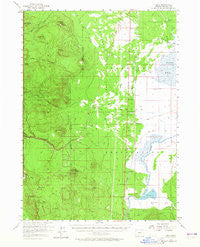
Lenz, Oregon, USGS topographic map dated 1957.
Includes geographic coordinates (latitude and longitude). This topographic map is suitable for hiking, camping, and exploring, or framing it as a wall map.
Printed on-demand using high resolution imagery, on heavy weight and acid free paper, or alternatively on a variety of synthetic materials.
Topos available on paper, Waterproof, Poly, or Tyvek. Usually shipping rolled, unless combined with other folded maps in one order.
- Product Number: USGS-5544974
- Free digital map download (high-resolution, GeoPDF): Lenz, Oregon (file size: 6 MB)
- Map Size: please refer to the dimensions of the GeoPDF map above
- Weight (paper map): ca. 55 grams
- Map Type: POD USGS Topographic Map
- Map Series: HTMC
- Map Verison: Historical
- Cell ID: 56654
- Scan ID: 282657
- Imprint Year: 1965
- Woodland Tint: Yes
- Aerial Photo Year: 1955
- Datum: NAD27
- Map Projection: Polyconic
- Map published by United States Geological Survey
- Map Language: English
- Scanner Resolution: 600 dpi
- Map Cell Name: Lenz
- Grid size: 15 X 15 Minute
- Date on map: 1957
- Map Scale: 1:62500
- Geographical region: Oregon, United States
Neighboring Maps:
All neighboring USGS topo maps are available for sale online at a variety of scales.
Spatial coverage:
Topo map Lenz, Oregon, covers the geographical area associated the following places:
- Pothole Well Guard Station - Lenz - Scott Creek Recreation Site - Big Springs - Dry Butte - Pothole Butte - Pothole Creek - Lenz Creek - Pothole Spring - Sand Creek Junction - Fuego - Chinchalo - Winema Post Office (historical) - Sand Creek Canal - Scott Creek - Hobbs Ditch - Wheeler Creek - Sun Mountain - Egan Springs - Thunder Beast Park - Hog Creek - Sun Pass - Sand Ridge - Boundary Butte - Lenz Ranch - Bear Butte - Sand Creek - Cow Creek - Gerwick Ditch - Cavern Creek - Pothole Well - Lookout Butte - Soloman Flat - Antelope Desert - Scout Hill - Yamsay Land and Cattle Company Ditch - Sand Creek
- Map Area ID: AREA4342.75-122-121.75
- Northwest corner Lat/Long code: USGSNW43-122
- Northeast corner Lat/Long code: USGSNE43-121.75
- Southwest corner Lat/Long code: USGSSW42.75-122
- Southeast corner Lat/Long code: USGSSE42.75-121.75
- Northern map edge Latitude: 43
- Southern map edge Latitude: 42.75
- Western map edge Longitude: -122
- Eastern map edge Longitude: -121.75


