
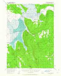
~ Klamath Marsh OR topo map, 1:62500 scale, 15 X 15 Minute, Historical, 1957, updated 1962
Klamath Marsh, Oregon, USGS topographic map dated 1957.
Includes geographic coordinates (latitude and longitude). This topographic map is suitable for hiking, camping, and exploring, or framing it as a wall map.
Printed on-demand using high resolution imagery, on heavy weight and acid free paper, or alternatively on a variety of synthetic materials.
Topos available on paper, Waterproof, Poly, or Tyvek. Usually shipping rolled, unless combined with other folded maps in one order.
- Product Number: USGS-5544924
- Free digital map download (high-resolution, GeoPDF): Klamath Marsh, Oregon (file size: 7 MB)
- Map Size: please refer to the dimensions of the GeoPDF map above
- Weight (paper map): ca. 55 grams
- Map Type: POD USGS Topographic Map
- Map Series: HTMC
- Map Verison: Historical
- Cell ID: 56251
- Scan ID: 282631
- Imprint Year: 1962
- Woodland Tint: Yes
- Aerial Photo Year: 1955
- Datum: NAD27
- Map Projection: Polyconic
- Map published by United States Geological Survey
- Map Language: English
- Scanner Resolution: 600 dpi
- Map Cell Name: Klamath Marsh
- Grid size: 15 X 15 Minute
- Date on map: 1957
- Map Scale: 1:62500
- Geographical region: Oregon, United States
Neighboring Maps:
All neighboring USGS topo maps are available for sale online at a variety of scales.
Spatial coverage:
Topo map Klamath Marsh, Oregon, covers the geographical area associated the following places:
- Yoss Creek Meadow - Meadow Creek - Little Wocus Butte - Abraham Flat - Summers Ranch - Williamson River Ditch - South Flat - Buckhorn Springs - Whitehouse Flat - Old Forest Camp - Jack Creek - Corral Spring - Lucky Reservoir - Dice Crane Spring - Copeland Spring - Big Springs Creek - Wocus Butte - Clover Creek - Bloody Point - Winema National Forest - Skellock Guard Station - Johnson Barn - Forest Spring - Kittredge Ranch - Lamm Camp - Military Crossing - Little Wocus Bay - John Cole Spring - Bluejay Spring Research Natural Area - Skellock Draw - Klamath Marsh National Wildlife Refuge - Hog Island - Recovery Spring - Wildhorse Ridge - Wocus Bay - Rocky Point - Wocus Bay Guard Station - Windmill Point - Kittredge Canal - Whitehouse Spring - South Fork Spring - Cabin Spring - Yoss Creek - Bluejay Spring - Wocus Butte Spring - Millhayes Meadow - The Peninsula - Lamm Crossing - Klamath Marsh - Indian Burial Ground - Y J Canal
- Map Area ID: AREA4342.75-121.75-121.5
- Northwest corner Lat/Long code: USGSNW43-121.75
- Northeast corner Lat/Long code: USGSNE43-121.5
- Southwest corner Lat/Long code: USGSSW42.75-121.75
- Southeast corner Lat/Long code: USGSSE42.75-121.5
- Northern map edge Latitude: 43
- Southern map edge Latitude: 42.75
- Western map edge Longitude: -121.75
- Eastern map edge Longitude: -121.5


