
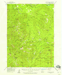
~ Garwood Butte OR topo map, 1:62500 scale, 15 X 15 Minute, Historical, 1956, updated 1958
Garwood Butte, Oregon, USGS topographic map dated 1956.
Includes geographic coordinates (latitude and longitude). This topographic map is suitable for hiking, camping, and exploring, or framing it as a wall map.
Printed on-demand using high resolution imagery, on heavy weight and acid free paper, or alternatively on a variety of synthetic materials.
Topos available on paper, Waterproof, Poly, or Tyvek. Usually shipping rolled, unless combined with other folded maps in one order.
- Product Number: USGS-5544722
- Free digital map download (high-resolution, GeoPDF): Garwood Butte, Oregon (file size: 9 MB)
- Map Size: please refer to the dimensions of the GeoPDF map above
- Weight (paper map): ca. 55 grams
- Map Type: POD USGS Topographic Map
- Map Series: HTMC
- Map Verison: Historical
- Cell ID: 54513
- Scan ID: 282517
- Imprint Year: 1958
- Woodland Tint: Yes
- Aerial Photo Year: 1953
- Field Check Year: 1956
- Datum: NAD27
- Map Projection: Polyconic
- Map published by United States Geological Survey
- Map Language: English
- Scanner Resolution: 600 dpi
- Map Cell Name: Garwood Butte
- Grid size: 15 X 15 Minute
- Date on map: 1956
- Map Scale: 1:62500
- Geographical region: Oregon, United States
Neighboring Maps:
All neighboring USGS topo maps are available for sale online at a variety of scales.
Spatial coverage:
Topo map Garwood Butte, Oregon, covers the geographical area associated the following places:
- Highrock Creek - West Fork Muir Creek - Rattlesnake Way - Camas Creek Campground - Lost Creek - Fish Creek Canal - Highrock Mountain - Stump Lake - No Tunnel Creek - Crescent Ridge - Triangle Lake - Hamaker Creek - Clearwater Canal Number 2 - Park Meadows - Poole Lake - Fish Creek Dam - Hamaker Bluff - Hamaker Recreation Site - Skookum Prairie Lookout - Foster Glades - Rough Creek Trail - Rolling Grounds Camp - Clear Creek - Mud Lake Mountain - Greek Creek - Wolf Lake - Fish Mountain - Garwood Butte - Minnehaha Creek - Watson Falls - Hummingbird Creek - Eva Creek - Devils Slide - Lava Creek - Gale Creek - Chinquapin Creek - Alkali Meadows - Sherwood Meadow - Rock Meadow - Falls Creek - Black Rock - Sherwood Creek - Beaver Meadows Trail - Buckneck Mountain - Mosquito Lake - Old Man Camp - Meadow Creek - Bear Creek - Log Creek - Jackass Mountain - National Creek Camp - Quartz Canyon - Bear Camp - Hershberger Mountain - Alkali Creek - Muir Creek Falls - Three Lakes - Windy Gap - Camp Creek - Hole in the Ground - Fawn Lake - Bobs Bay - Soda Spring - Sherwood Butte - Haymaker Campground - Minnehaha-Hurryon Trail - Dog Prairie Trail - Ice Creek - Rocky Ridge - Prineville Camp (historical) - Slide Creek - Trap Creek - Rock Creek - Horse Creek - Dog Prairie - Fish Creek Shelter - Buck Canyon - Skookum Creek - Rough Creek - Camas Creek - Trap Mountain - Grave Creek - Fish Creek Campground - Happy Valley - Pup Prairie - Weaver Mountain - Dog Prairie Creek - Rattlesnake Mountain - Mazama Creek - Lewis Camp - Fish Creek Reservoir - Rhododendron Ridge - Beartree Creek - Dog Prairie Shelter - Whitehorse Meadows - Skookum Prairie - Black Rock Trail - Fish Creek Valley - Fish Lake Trail - Buck Canyon Trail
- Map Area ID: AREA43.2543-122.5-122.25
- Northwest corner Lat/Long code: USGSNW43.25-122.5
- Northeast corner Lat/Long code: USGSNE43.25-122.25
- Southwest corner Lat/Long code: USGSSW43-122.5
- Southeast corner Lat/Long code: USGSSE43-122.25
- Northern map edge Latitude: 43.25
- Southern map edge Latitude: 43
- Western map edge Longitude: -122.5
- Eastern map edge Longitude: -122.25


