
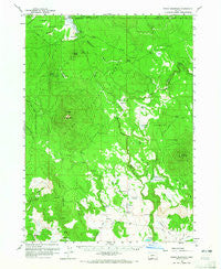
~ Fuego Mountain OR topo map, 1:62500 scale, 15 X 15 Minute, Historical, 1960, updated 1965
Fuego Mountain, Oregon, USGS topographic map dated 1960.
Includes geographic coordinates (latitude and longitude). This topographic map is suitable for hiking, camping, and exploring, or framing it as a wall map.
Printed on-demand using high resolution imagery, on heavy weight and acid free paper, or alternatively on a variety of synthetic materials.
Topos available on paper, Waterproof, Poly, or Tyvek. Usually shipping rolled, unless combined with other folded maps in one order.
- Product Number: USGS-5544700
- Free digital map download (high-resolution, GeoPDF): Fuego Mountain, Oregon (file size: 7 MB)
- Map Size: please refer to the dimensions of the GeoPDF map above
- Weight (paper map): ca. 55 grams
- Map Type: POD USGS Topographic Map
- Map Series: HTMC
- Map Verison: Historical
- Cell ID: 54426
- Scan ID: 282506
- Imprint Year: 1965
- Woodland Tint: Yes
- Aerial Photo Year: 1956
- Datum: NAD27
- Map Projection: Polyconic
- Map published by United States Geological Survey
- Map Language: English
- Scanner Resolution: 600 dpi
- Map Cell Name: Fuego Mountain
- Grid size: 15 X 15 Minute
- Date on map: 1960
- Map Scale: 1:62500
- Geographical region: Oregon, United States
Neighboring Maps:
All neighboring USGS topo maps are available for sale online at a variety of scales.
Spatial coverage:
Topo map Fuego Mountain, Oregon, covers the geographical area associated the following places:
- Tree House Pond - Spodue Mountain - Bob Plank Spring - Wild Billy Lake - Wildhorse Meadow - Guard Pond - Essex Springs - Blue Creek Spring - Wildhorse Spring - Willow Pond - Buck Spring Pond - Black Hills Lookout - Dibbon Cook Spring - Silver Dollar Cinder Pit - Moondance Ranch Airport - Wildhorse Reservoir - Deer Draw - Buckmaster Point - Godowa Spring - Pelican Reservoir - Head of the River Recreation Site - Blue Creek Meadows - Milk Creek - Yamsay Guard Station - Torrent Spring - Williamson River Spring - Bitter Spring - Raymonds Camp (historical) - Rose Mary Pond - High Table Pond - Sycan Ford - Yamsay Ranch - Cottonwood Springs - Raymonds Pond - Cooks Mountain - Taylor Butte - Yamsay Spring - Little Hole Reservoir - Teddy Powers Meadow - Yamsi Reservoir - Chipps Spring - Bottle Spring - Horse Butte - Pelican Bay Camp (historical) - Chester Spring - Elde Flat - Rock Spring - Coyote Bucket - Silver Dollar Flat - Fuego Mountain - Coyote Spring - Knife Pond - Brown Spring - Airstrip Pond - Tim Brown Spring - Coyote Bucket Pond - Some Chance Pond - High Tableland - Cordelia Flat - Blue Creek - Brush Spring
- Map Area ID: AREA42.7542.5-121.5-121.25
- Northwest corner Lat/Long code: USGSNW42.75-121.5
- Northeast corner Lat/Long code: USGSNE42.75-121.25
- Southwest corner Lat/Long code: USGSSW42.5-121.5
- Southeast corner Lat/Long code: USGSSE42.5-121.25
- Northern map edge Latitude: 42.75
- Southern map edge Latitude: 42.5
- Western map edge Longitude: -121.5
- Eastern map edge Longitude: -121.25


