
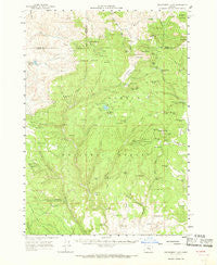
~ Delintment Lake OR topo map, 1:62500 scale, 15 X 15 Minute, Historical, 1961, updated 1968
Delintment Lake, Oregon, USGS topographic map dated 1961.
Includes geographic coordinates (latitude and longitude). This topographic map is suitable for hiking, camping, and exploring, or framing it as a wall map.
Printed on-demand using high resolution imagery, on heavy weight and acid free paper, or alternatively on a variety of synthetic materials.
Topos available on paper, Waterproof, Poly, or Tyvek. Usually shipping rolled, unless combined with other folded maps in one order.
- Product Number: USGS-5544514
- Free digital map download (high-resolution, GeoPDF): Delintment Lake, Oregon (file size: 8 MB)
- Map Size: please refer to the dimensions of the GeoPDF map above
- Weight (paper map): ca. 55 grams
- Map Type: POD USGS Topographic Map
- Map Series: HTMC
- Map Verison: Historical
- Cell ID: 53321
- Scan ID: 282412
- Imprint Year: 1968
- Woodland Tint: Yes
- Aerial Photo Year: 1957
- Field Check Year: 1961
- Datum: NAD27
- Map Projection: Polyconic
- Map published by United States Geological Survey
- Map Language: English
- Scanner Resolution: 600 dpi
- Map Cell Name: Delintment Lake
- Grid size: 15 X 15 Minute
- Date on map: 1961
- Map Scale: 1:62500
- Geographical region: Oregon, United States
Neighboring Maps:
All neighboring USGS topo maps are available for sale online at a variety of scales.
Spatial coverage:
Topo map Delintment Lake, Oregon, covers the geographical area associated the following places:
- Beaver Reservoir - Snow Mountain Spring - Sherman Ranch - Grindstone Reservoir - Association Corral (historical) - Boone Prairie - Adams Spring - Pigeon Spring - Buck Spring Guard Station (historical) - Porcupine Spring - Sawmill Creek Camp - Tip Top Spring - Grindstone Dam - Lehman Meadow - Williams Reservoir - Still Spring - Gravelly Flat - Roadside Spring - Perkins Spring - J M Ranch - Delintment Lake - Chapin Table - Dobson Creek - Bullseye Spring - Delintment Lake Recreation Site - Clear Creek - Sourdough Spring - Snow Spring - Warm Springs - Tamarack Creek - Blue Jay Spring - Salt Canyon Spring - Beaver Dam Spring - Delintment Lake Dam - Jimmy McCuen Spring - Allison Guard Station - Rimrock Spring - Sawmill Number Two Reservoir - Dry Dam Reservoir - Sherman Spring - Little Mowich Mountain - Harpham Spring - Stinking Spring - Timothy Spring - Twin Spring Reservoir - Upper Sherman Ranch (historical) - Salt Canyon - Buck Spring Creek - Pole Camp Spring - Mutton Camp - Mill Spring - Dustbox Spring - Allison Ranger Station - Dobson Spring - Pinkie Spring - Allen Spring - Allison Ranch - Mud Spring - Fine Spring - Moco Spring - Deadhorse Spring - Allison Creek - Cow Camp - Delintment Creek - Round Meadow Spring - Fawn Spring - Boundary Spring - Buck Spring Campground - Mill Reservoir - Mutton Creek - Upper Crowsfoot Spring - Helens Spring - Swain Prairie Spring - Buck Spring - Whistle Creek - Pendleton Spring - Twelvemile Dam - Silver Spring - Foss Spring - Delintment Lake Boat Ramp - Button Flat - Dodson Creek - Packsaddle Spring - Willow Spring - DK Spring - Weburg Spring - Little Howard Spring - Mills Upper Ranch - Lake Spring - Gilchrist Spring - Copper Creek - Bixby Spring - Sawmill Number One Reservoir - Big Howard Spring - Short Creek - Iron Mountain - Freeman Creek - Button Flat Spring - Robertson Ranch - Pick Spring
- Map Area ID: AREA4443.75-119.75-119.5
- Northwest corner Lat/Long code: USGSNW44-119.75
- Northeast corner Lat/Long code: USGSNE44-119.5
- Southwest corner Lat/Long code: USGSSW43.75-119.75
- Southeast corner Lat/Long code: USGSSE43.75-119.5
- Northern map edge Latitude: 44
- Southern map edge Latitude: 43.75
- Western map edge Longitude: -119.75
- Eastern map edge Longitude: -119.5


