
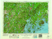
~ Bangor ME topo map, 1:250000 scale, 1 X 2 Degree, Historical, 1961, updated 1961
Bangor, Maine, USGS topographic map dated 1961.
Includes geographic coordinates (latitude and longitude). This topographic map is suitable for hiking, camping, and exploring, or framing it as a wall map.
Printed on-demand using high resolution imagery, on heavy weight and acid free paper, or alternatively on a variety of synthetic materials.
Topos available on paper, Waterproof, Poly, or Tyvek. Usually shipping rolled, unless combined with other folded maps in one order.
- Product Number: USGS-5537431
- Free digital map download (high-resolution, GeoPDF): Bangor, Maine (file size: 17 MB)
- Map Size: please refer to the dimensions of the GeoPDF map above
- Weight (paper map): ca. 55 grams
- Map Type: POD USGS Topographic Map
- Map Series: HTMC
- Map Verison: Historical
- Cell ID: 68662
- Scan ID: 806482
- Imprint Year: 1961
- Woodland Tint: Yes
- Field Check Year: 1956
- Datum: Unstated
- Map Projection: Transverse Mercator
- Map published by United States Army Corps of Engineers
- Map published by United States Army
- Map Language: English
- Scanner Resolution: 508 dpi
- Map Cell Name: Bangor
- Grid size: 1 X 2 Degree
- Date on map: 1961
- Map Scale: 1:250000
- Geographical region: Maine, United States
Neighboring Maps:
All neighboring USGS topo maps are available for sale online at a variety of scales.
Spatial coverage:
Topo map Bangor, Maine, covers the geographical area associated the following places:
- North Pittston - Emerson Corner - Decker Corner - Kennedy Corner - Larone - Varney Corner - Cold Brook - Wilson Corner - Somesville - Town Hill - Waltham - Marlboro - Union - South Corinth - Myra - Searsmont - Bog Corner - East Friendship - East Benton - Sargentville - Bangor - Castle Harmony - West Searsmont - West Sidney - Willis Corners - Oceanville - Bar Harbor - Damascus - Yorks Corner - Tyler Corner - Stonington - Palermo - Seawall - Readfield Depot - Burkettville - Polands Corner - Flanders Corner - North Windsor - Swanville - West Gouldsboro - Glendon - Pauls Corner - Togus - Beans Corner - Townhouse Corner - Martells Mobile Home Court - Drake Corner - Eastbrook - Knox Hill Corner - Burton Corner - Islesford - West Tremont - Crescent Beach - Lyford Corner - Phillips Corner - Clifton - Pitmans Corner - Hermon Center - Indian Point - Lucerne-in-Maine - Goose Rocks - Halls Corner - Smithfield - Morrill - Newburgh Village - Hayford Corner - Gregorys Corner - Riverside - Great Works - Winkumpaugh Corners - Lakewood - Holden - Norridgewock - West Waldoboro - Coopers Mills - Bayside - Mercer - Mainstream - Owls Head - Solon - Burnham - Gould Corner - Hancock - Martin Corner - Vinalhaven - Mitchell Corner - Waverley - Hampden Highlands - Harrington Corner - Grants Turn - East Blue Hill - Surry - Red Rock Corner - Pittsfield - Kenduskeag - Ghent - Marsh Corner - Goodwin Siding - Exeter Mills - North Sidney
- Map Area ID: AREA4544-70-68
- Northwest corner Lat/Long code: USGSNW45-70
- Northeast corner Lat/Long code: USGSNE45-68
- Southwest corner Lat/Long code: USGSSW44-70
- Southeast corner Lat/Long code: USGSSE44-68
- Northern map edge Latitude: 45
- Southern map edge Latitude: 44
- Western map edge Longitude: -70
- Eastern map edge Longitude: -68


