
~ Bangor ME topo map, 1:250000 scale, 1 X 2 Degree, Historical, 1956, updated 1984
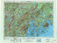
Bangor, Maine, USGS topographic map dated 1956.
Includes geographic coordinates (latitude and longitude). This topographic map is suitable for hiking, camping, and exploring, or framing it as a wall map.
Printed on-demand using high resolution imagery, on heavy weight and acid free paper, or alternatively on a variety of synthetic materials.
Topos available on paper, Waterproof, Poly, or Tyvek. Usually shipping rolled, unless combined with other folded maps in one order.
- Product Number: USGS-5537425
- Free digital map download (high-resolution, GeoPDF): Bangor, Maine (file size: 21 MB)
- Map Size: please refer to the dimensions of the GeoPDF map above
- Weight (paper map): ca. 55 grams
- Map Type: POD USGS Topographic Map
- Map Series: HTMC
- Map Verison: Historical
- Cell ID: 68662
- Scan ID: 806479
- Imprint Year: 1984
- Woodland Tint: Yes
- Edit Year: 1965
- Field Check Year: 1956
- Datum: Unstated
- Map Projection: Transverse Mercator
- Map published by United States Army Corps of Engineers
- Map published by United States Army
- Map Language: English
- Scanner Resolution: 508 dpi
- Map Cell Name: Bangor
- Grid size: 1 X 2 Degree
- Date on map: 1956
- Map Scale: 1:250000
- Geographical region: Maine, United States
Neighboring Maps:
All neighboring USGS topo maps are available for sale online at a variety of scales.
Spatial coverage:
Topo map Bangor, Maine, covers the geographical area associated the following places:
- Belfast - Arey - Richtown - Bryants Corner - Sunset - Randolph - Frankfort - Sandy River - Harwards - West Palmyra - Bangs Beach - Etna Center - North Appleton - Seal Harbor - Simpsons Corner - Rowe Corner - Athearns Corner - West Washington - Eddington - Gouldsboro - Cape Rosier - North Winterport - French Mill - Dog Island Corner - Gerrishville - Skowhegan - Hermon Center - Clifton - Exeter Center - Richs Corner - North Deer Isle - Connors Corner - Stubbs Corner - Dodge Corner - Head of the Tide - Monroe Center - Knox Ledge Corner - Tacoma - Franklin Road - West Castine - Gushees Corner - Maranacook - North Searsport - Cranes Corners - Dane Corner - Winthrop - Grange Corner - West Montville - Flat Landing - North Windsor - Whitcombs Corner - Benton Falls - West Athens - Alna Center - Washington Junction - North Pittston - Otis - Togus - Dunns Corners - Sibley Corner - Pleasant Vale Corner - Rainbow Home Court Mobile Home Park - East Dixmont - Eggemoggin - Sand Beach - Etna - Hulls Cove - North Ellsworth - Searsmont - Toulouse Corner - Rockville - Winslow - Knights Corner - Arnold Corner - Farmingdale - Brooklin - Butlers Corner - Hampden Center - West Levant - Carvers Corner - Dixie Corner - Waldoboro - Sedgwick - Corsons Corner - Tyler Corner - Bucksport - Blue Hill - Yorks Corner - Anson - Miles Corner - West Windsor - Gould Corner - Pease Corner - Sennetts Corner - Hancock - Ellingwood Corner - Green Lake - Unity - North Haven - Liberty
- Map Area ID: AREA4544-70-68
- Northwest corner Lat/Long code: USGSNW45-70
- Northeast corner Lat/Long code: USGSNE45-68
- Southwest corner Lat/Long code: USGSSW44-70
- Southeast corner Lat/Long code: USGSSE44-68
- Northern map edge Latitude: 45
- Southern map edge Latitude: 44
- Western map edge Longitude: -70
- Eastern map edge Longitude: -68


