
~ Bangor ME topo map, 1:250000 scale, 1 X 2 Degree, Historical, 1948, updated 1948
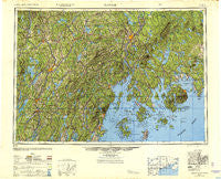
Bangor, Maine, USGS topographic map dated 1948.
Includes geographic coordinates (latitude and longitude). This topographic map is suitable for hiking, camping, and exploring, or framing it as a wall map.
Printed on-demand using high resolution imagery, on heavy weight and acid free paper, or alternatively on a variety of synthetic materials.
Topos available on paper, Waterproof, Poly, or Tyvek. Usually shipping rolled, unless combined with other folded maps in one order.
- Product Number: USGS-5537423
- Free digital map download (high-resolution, GeoPDF): Bangor, Maine (file size: 18 MB)
- Map Size: please refer to the dimensions of the GeoPDF map above
- Weight (paper map): ca. 55 grams
- Map Type: POD USGS Topographic Map
- Map Series: HTMC
- Map Verison: Historical
- Cell ID: 68662
- Scan ID: 707211
- Imprint Year: 1948
- Woodland Tint: Yes
- Aerial Photo Year: 1944
- Datum: NAD27
- Map Projection: Transverse Mercator
- Shaded Relief map: Yes
- Map published by United States Army Corps of Engineers
- Map published by United States Army
- Map Language: English
- Scanner Resolution: 508 dpi
- Map Cell Name: Bangor
- Grid size: 1 X 2 Degree
- Date on map: 1948
- Map Scale: 1:250000
- Geographical region: Maine, United States
Neighboring Maps:
All neighboring USGS topo maps are available for sale online at a variety of scales.
Spatial coverage:
Topo map Bangor, Maine, covers the geographical area associated the following places:
- Saint George - Detroit - Bayside - West Gouldsboro - Eddington - West Franklin - Skowhegan - Goodwin Siding - South Windsor - South Surry - Townhouse Corner - Bar Harbor - Iceboro - Randolph - Beddington - Hampden - Frenchs Corner - Troy - Rice Corner - South Solon - Woodmans Mills - Thompson Corner - Harborside - South Gouldsboro - Camden - West Penobscot - Eggemoggin - Winter Harbor - Sandy Beach - Heals Corner - Hermon - Head of the Tide - Prospect Ferry - Ash Point - Alna Center - Payson Corner - Marsh Corner - Aurora - Athearns Corner - Benton Station - Purgatory - Castine - North Monroe - Liberty - North Dixmont - Shawmut - West Bangor - East Union - Stonington - Indian Point - Hales Corner - Yorks Corner - West Waldoboro - Lucerne-in-Maine - East Madison - South Blue Hill - Maddocks Corner - Dark Harbor - Winslow Hill - Morrison Corner - Benton - Halls Corner - McGregor Mill - North Hope Corner - Litchfield Plains - Varney Corner - East Exeter - Frenchboro - Nehumkeag (historical) - Vickerys Corner - Northeast Harbor - South Montville - Windsorville - Sandhill Corner - Jones Corner - Great Pond - Greers Corner - Dirigo Corner - Grange Corner - Old Town Landing - Beans Corner - West Appleton - Flanders Corner - Barron Corner - Bowdoin Center - Windemere - Stillwater Avenue - Arey - Shermans Corner - Island Park - Blue Hill Falls - Blackinton Corners - Monroe - Turners Corner - Lower Beddington - Nicolin (historical) - East Hampden - Hinckley - Albion - West Trenton
- Map Area ID: AREA4544-70-68
- Northwest corner Lat/Long code: USGSNW45-70
- Northeast corner Lat/Long code: USGSNE45-68
- Southwest corner Lat/Long code: USGSSW44-70
- Southeast corner Lat/Long code: USGSSE44-68
- Northern map edge Latitude: 45
- Southern map edge Latitude: 44
- Western map edge Longitude: -70
- Eastern map edge Longitude: -68


