
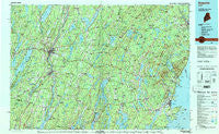
~ Augusta ME topo map, 1:100000 scale, 30 X 60 Minute, Historical, 1984, updated 1984
Augusta, Maine, USGS topographic map dated 1984.
Includes geographic coordinates (latitude and longitude). This topographic map is suitable for hiking, camping, and exploring, or framing it as a wall map.
Printed on-demand using high resolution imagery, on heavy weight and acid free paper, or alternatively on a variety of synthetic materials.
Topos available on paper, Waterproof, Poly, or Tyvek. Usually shipping rolled, unless combined with other folded maps in one order.
- Product Number: USGS-5537323
- Free digital map download (high-resolution, GeoPDF): Augusta, Maine (file size: 26 MB)
- Map Size: please refer to the dimensions of the GeoPDF map above
- Weight (paper map): ca. 55 grams
- Map Type: POD USGS Topographic Map
- Map Series: HTMC
- Map Verison: Historical
- Cell ID: 67081
- Scan ID: 806470
- Imprint Year: 1984
- Woodland Tint: Yes
- Aerial Photo Year: 1976
- Edit Year: 1984
- Datum: NAD27
- Map Projection: Universal Transverse Mercator
- Map published by United States Geological Survey
- Map Language: English
- Scanner Resolution: 508 dpi
- Map Cell Name: Augusta
- Grid size: 30 X 60 Minute
- Date on map: 1984
- Map Scale: 1:100000
- Geographical region: Maine, United States
Neighboring Maps:
All neighboring USGS topo maps are available for sale online at a variety of scales.
Spatial coverage:
Topo map Augusta, Maine, covers the geographical area associated the following places:
- North Whitefield - East Winthrop - Cushing - Libby Hill - Locks Corner - Hurds Corner - Coopers Mills - North Sidney - Alna - West Rockport - West Washington - Vickerys Corner - Stickney Corner - Lake City - Pitmans Corner - South Newcastle - Smithton - Manchester - Feylers Corner - North Cushing - Benner Corner - Waldoboro - Glendon - Alna Center - McCoy Crossing - Appleton - Belfast - Winthrop Center - Harrington Corner - North Newcastle - Thurstons Corner - West Sidney - Grants Turn - Whites Corner - West Appleton - Whitcombs Corner - White Oak Corner - Richmond Corner - East Friendship - South Montville - Richmond - Lucas Corner - North Windsor - Holmes Mill - Liberty - South China - West Searsmont - Tallwood - Razorville - Youngtown - Sprague Corner - Bacons Corner - Kendalls Corner - Damariscotta - Iceboro - Whitney Corner - Bogues Corner - Glen Cove - Carrs Corner - Dunns Corners - Spears Corner - Sidney - Wattons Mill - Riverside - Proctors Corner - Simpsons Corner - North Jefferson - Augusta - Center Belmont - Martins Corner - Davis Corner - South Warren - Polands Corner - Windsor - Simonton Corners - Searsmont - Camden - Bowdoinham - Dirigo Corner - Cedar Grove - Wiscasset - Bangs Beach - Gregorys Corner - Shermans Corner - Warren - Kalers Corner - Vassalboro - Townhouse Corner - Greenlaws Corner - Whitefield - Ash Point - Coles - Dresden Mills - Ring Hill - Rockville - South Jefferson - North Vassalboro - Rockport - Eugley Corner - Palermo
- Map Area ID: AREA44.544-70-69
- Northwest corner Lat/Long code: USGSNW44.5-70
- Northeast corner Lat/Long code: USGSNE44.5-69
- Southwest corner Lat/Long code: USGSSW44-70
- Southeast corner Lat/Long code: USGSSE44-69
- Northern map edge Latitude: 44.5
- Southern map edge Latitude: 44
- Western map edge Longitude: -70
- Eastern map edge Longitude: -69


